
Make a donation
Gear up for your next adventure:
As an Amazon Associate, this site earns from qualifying purchases at no extra cost to you.
McKay Lake topographic map
Click on the map to display elevation.
Make a donation
Gear up for your next adventure:
As an Amazon Associate, this site earns from qualifying purchases at no extra cost to you.
About this map
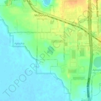
Name: McKay Lake topographic map, elevation, terrain.
Location: McKay Lake, Apopka, Orange County, Florida, United States (28.68852 -81.57222 28.69084 -81.57011)
Average elevation: 29 m
Minimum elevation: 17 m
Maximum elevation: 49 m
Make a donation
Gear up for your next adventure:
As an Amazon Associate, this site earns from qualifying purchases at no extra cost to you.
Other topographic maps
Click on a map to view its topography, its elevation and its terrain.
Make a donation
Gear up for your next adventure:
As an Amazon Associate, this site earns from qualifying purchases at no extra cost to you.
Make a donation
Gear up for your next adventure:
As an Amazon Associate, this site earns from qualifying purchases at no extra cost to you.
Winter Park
United States > Florida > Orange County
The city is northeast of and adjacent to Orlando. Elevation ranges between 66 and 97 feet (20 and 30 m) above sea level.
Average elevation: 30 m