Geolocate

Barnett Park topographic map

Click on the map to display elevation.

About this map

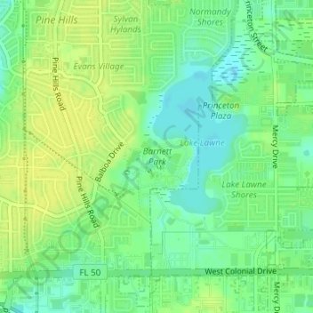
Name: Barnett Park topographic map, elevation, terrain.

Location: Barnett Park, Orange County, Florida, United States (28.55613 -81.44760 28.56899 -81.43811)

Average elevation: 32 m

Minimum elevation: 22 m

Maximum elevation: 40 m

Other topographic maps

Click on a map to view its topography, its elevation and its terrain.

Orlando

United States > Florida > Orange County

Average elevation: 29 m

Christmas

United States > Florida > Orange County

Average elevation: 15 m

Lockwood

United States > Florida > Orange County

Average elevation: 20 m

McKay Lake

United States > Florida > Orange County

Average elevation: 29 m

Doe Lake

United States > Florida > Orange County

Average elevation: 36 m

Gear up for your next adventure:

🧦Hiking Liner Socks - Thin base layer to prevent friction and blisters
🧥Waterproof Hiking Jacket - Protect yourself from rain and wind while hiking
Lightweight Backpacking Tent - Compact tent for efficient hiking trips
🧰Multitool Knife - Compact and versatile tool for outdoor use
🧥Waterproof Jacket - Lightweight rain jackets for hiking and outdoor activities

As an Amazon Associate, this site earns from qualifying purchases at no extra cost to you.