Geolocate

Maitland topographic map

Click on the map to display elevation.

About this map

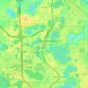
Name: Maitland topographic map, elevation, terrain.

Location: Maitland, Orange County, Florida, 32751, United States (28.60952 -81.41082 28.64041 -81.32834)

Average elevation: 30 m

Minimum elevation: 14 m

Maximum elevation: 46 m

Other topographic maps

Click on a map to view its topography, its elevation and its terrain.

Orlando

United States > Florida > Orange County

Average elevation: 29 m

Christmas

United States > Florida > Orange County

Average elevation: 15 m

Lockwood

United States > Florida > Orange County

Average elevation: 20 m

McKay Lake

United States > Florida > Orange County

Average elevation: 29 m

Doe Lake

United States > Florida > Orange County

Average elevation: 36 m

Gear up for your next adventure:

🛏️Camping Sleeping Mat - Comfortable mats for sleeping outdoors
🛌Down Sleeping Bag - Superior warmth-to-weight ratio for cold nights
🥾Waterproof Hiking Boots - Essential footwear for rugged terrain and wet Canadian trails
🧴First Aid Kit - Essential first aid supplies for outdoor emergencies
Camping Groundsheet - Protect your tent from moisture and dirt

As an Amazon Associate, this site earns from qualifying purchases at no extra cost to you.