
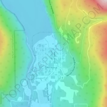
Slocan topographic map
Interactive map
Click on the map to display elevation.
About this map
Name: Slocan topographic map, elevation, terrain.
Average elevation: 665 m
Minimum elevation: 532 m
Maximum elevation: 1,050 m
Other topographic maps
Click on a map to view its topography, its elevation and its terrain.
Nelson
Canada > British Columbia > Regional District of Central Kootenay
Nelson, Regional District of Central Kootenay, British Columbia, Canada
Average elevation: 1,325 m
Castlegar
Canada > British Columbia > Regional District of Central Kootenay
Castlegar, Regional District of Central Kootenay, British Columbia, Canada
Average elevation: 831 m
Ymir
Canada > British Columbia > Regional District of Central Kootenay > Area G (Salmo Valley)
Ymir, Area G (Salmo Valley), Regional District of Central Kootenay, British Columbia, Canada
Average elevation: 967 m
West Arm Provincial Park
Canada > British Columbia > Regional District of Central Kootenay > Area E (Balfour/Cottonwood Lake)
West Arm Provincial Park, Area E (Balfour/Cottonwood Lake), Regional District of Central Kootenay, British Columbia, Canada
Average elevation: 1,449 m
Granite
Canada > British Columbia > Regional District of Central Kootenay > Area E (Balfour/Cottonwood Lake) > Blewett
Granite, Blewett, Area E (Balfour/Cottonwood Lake), Regional District of Central Kootenay, British Columbia, V1L 6X4, Canada
Average elevation: 772 m
Creston
Canada > British Columbia > Regional District of Central Kootenay
Creston, Regional District of Central Kootenay, British Columbia, Canada
Average elevation: 738 m
Cooper Creek
Canada > British Columbia > Regional District of Central Kootenay > Area D (Lardeau Valley/Duncan Lake)
Cooper Creek, Area D (Lardeau Valley/Duncan Lake), Regional District of Central Kootenay, British Columbia, Canada
Average elevation: 1,573 m
Kootenay Lake
Canada > British Columbia > Regional District of Central Kootenay
Kootenay Lake, Regional District of Central Kootenay, British Columbia, Canada
Average elevation: 1,609 m
Poplar Creek
Canada > British Columbia > Regional District of Central Kootenay > Area D (Lardeau Valley/Duncan Lake)
Poplar Creek, Area D (Lardeau Valley/Duncan Lake), Regional District of Central Kootenay, British Columbia, Canada
Average elevation: 1,732 m
Silent Pass
Canada > British Columbia > Regional District of Central Kootenay > Area D (Lardeau Valley/Duncan Lake)
Silent Pass, Area D (Lardeau Valley/Duncan Lake), Regional District of Central Kootenay, British Columbia, Canada
Average elevation: 2,100 m
Goat River
Canada > British Columbia > Regional District of Central Kootenay > Area B (Goat River Valley)
Goat River, Area B (Goat River Valley), Regional District of Central Kootenay, British Columbia, Canada
Average elevation: 1,713 m
Area H (The Slocan Valley)
Canada > British Columbia > Regional District of Central Kootenay
Area H (The Slocan Valley), Regional District of Central Kootenay, British Columbia, Canada
Average elevation: 1,426 m
Ross-White Lady Lake Recreation Site
Canada > British Columbia > Regional District of Central Kootenay > Area E (Balfour/Cottonwood Lake)
Ross-White Lady Lake Recreation Site, Area E (Balfour/Cottonwood Lake), Regional District of Central Kootenay, British Columbia, Canada
Average elevation: 1,858 m
Area J (Lower Arrow/Columbia)
Canada > British Columbia > Regional District of Central Kootenay
Area J (Lower Arrow/Columbia), Regional District of Central Kootenay, British Columbia, Canada
Average elevation: 1,329 m
Keen Creek
Canada > British Columbia > Regional District of Central Kootenay > Area D (Lardeau Valley/Duncan Lake)
Keen Creek, Area D (Lardeau Valley/Duncan Lake), Regional District of Central Kootenay, British Columbia, Canada
Average elevation: 976 m
Nakusp
Canada > British Columbia > Regional District of Central Kootenay
Nakusp, Regional District of Central Kootenay, British Columbia, Canada
Average elevation: 752 m
Taghum
Canada > British Columbia > Regional District of Central Kootenay > Area F (Kokanee Range)
Taghum, Area F (Kokanee Range), Regional District of Central Kootenay, British Columbia, V1L 6X4, Canada
Average elevation: 745 m
Kaslo
Canada > British Columbia > Regional District of Central Kootenay
Kaslo, Regional District of Central Kootenay, British Columbia, Canada
Average elevation: 591 m
Stoney Creek
Canada > British Columbia > Regional District of Central Kootenay > Area K (The Arrow Lakes)
Stoney Creek, Area K (The Arrow Lakes), Regional District of Central Kootenay, British Columbia, Canada
Average elevation: 1,295 m
Boswell
Canada > British Columbia > Regional District of Central Kootenay > Area A (Wynndel/Crawford Bay/Riondel)
Boswell, Area A (Wynndel/Crawford Bay/Riondel), Regional District of Central Kootenay, British Columbia, V0B 1A0, Canada
Average elevation: 779 m
Crawford Bay
Canada > British Columbia > Regional District of Central Kootenay > Area A (Wynndel/Crawford Bay/Riondel)
Crawford Bay, Area A (Wynndel/Crawford Bay/Riondel), Regional District of Central Kootenay, British Columbia, V0B 1E0, Canada
Average elevation: 667 m
Area K (The Arrow Lakes)
Canada > British Columbia > Regional District of Central Kootenay
Area K (The Arrow Lakes), Regional District of Central Kootenay, British Columbia, Canada
Average elevation: 1,452 m
Kitchener
Canada > British Columbia > Regional District of Central Kootenay > Area B
Kitchener, Area B, Regional District of Central Kootenay, British Columbia, Canada
Average elevation: 925 m
Salmo
Canada > British Columbia > Regional District of Central Kootenay
Salmo, Regional District of Central Kootenay, British Columbia, Canada
Average elevation: 715 m
Pass Creek
Canada > British Columbia > Regional District of Central Kootenay > Area I (Sentinel Mountain)
Pass Creek, Area I (Sentinel Mountain), Regional District of Central Kootenay, British Columbia, Canada
Average elevation: 751 m
Kootenay Canal
Canada > British Columbia > Regional District of Central Kootenay > Nelson
Kootenay Canal, Nelson, Regional District of Central Kootenay, British Columbia, Canada
Average elevation: 663 m
Ainsworth Hot Springs
Canada > British Columbia > Regional District of Central Kootenay > Area D (Lardeau Valley/Duncan Lake)
Ainsworth Hot Springs, Area D (Lardeau Valley/Duncan Lake), Regional District of Central Kootenay, British Columbia, V0G 1A0, Canada
Average elevation: 741 m
Bentz Peak
Canada > British Columbia > Regional District of Central Kootenay > Area J (Lower Arrow/Columbia)
Bentz Peak, Area J (Lower Arrow/Columbia), Regional District of Central Kootenay, British Columbia, Canada
Average elevation: 2,037 m
Playmor Junction
Canada > British Columbia > Regional District of Central Kootenay > Area H (The Slocan Valley) > South Slocan
Playmor Junction, South Slocan, Area H (The Slocan Valley), Regional District of Central Kootenay, British Columbia, V0G 2G0, Canada
Average elevation: 578 m
Blewett
Canada > British Columbia > Regional District of Central Kootenay > Area E (Balfour/Cottonwood Lake) > Blewett
Blewett, Area E (Balfour/Cottonwood Lake), Regional District of Central Kootenay, British Columbia, V1L 6X4, Canada
Average elevation: 837 m
Winlaw
Canada > British Columbia > Regional District of Central Kootenay > Area H (The Slocan Valley)
Winlaw, Area H (The Slocan Valley), Regional District of Central Kootenay, British Columbia, V0G 2J0, Canada
Average elevation: 694 m
Burton
Canada > British Columbia > Regional District of Central Kootenay > Area K (The Arrow Lakes)
Burton, Area K (The Arrow Lakes), Regional District of Central Kootenay, British Columbia, V0G 1E0, Canada
Average elevation: 578 m
Lemon Creek
Canada > British Columbia > Regional District of Central Kootenay > Area H (The Slocan Valley)
Lemon Creek, Area H (The Slocan Valley), Regional District of Central Kootenay, British Columbia, Canada
Average elevation: 1,527 m
Castlegar
Canada > British Columbia > Regional District of Central Kootenay > Castlegar
Castlegar, Regional District of Central Kootenay, British Columbia, V1N 1H4, Canada
Average elevation: 1,207 m
Area E (Balfour/Cottonwood Lake)
Canada > British Columbia > Regional District of Central Kootenay > Area E (Balfour/Cottonwood Lake)
Area E (Balfour/Cottonwood Lake), Regional District of Central Kootenay, British Columbia, Canada
Average elevation: 1,433 m
Area A (Wynndel/Crawford Bay/Riondel)
Canada > British Columbia > Regional District of Central Kootenay
Area A (Wynndel/Crawford Bay/Riondel), Regional District of Central Kootenay, British Columbia, Canada
Average elevation: 1,574 m
Kokanee Creek Provincial Park
Canada > British Columbia > Regional District of Central Kootenay > Area E (Balfour/Cottonwood Lake)
Kokanee Creek Provincial Park, Area E (Balfour/Cottonwood Lake), Regional District of Central Kootenay, British Columbia, Canada
Average elevation: 617 m
Area G (Salmo Valley)
Canada > British Columbia > Regional District of Central Kootenay
Area G (Salmo Valley), Regional District of Central Kootenay, British Columbia, V0G 1Z0, Canada
Average elevation: 1,395 m
Area C
Canada > British Columbia > Regional District of Central Kootenay > Area C
Area C, Regional District of Central Kootenay, British Columbia, V0B 1G7, Canada
Average elevation: 1,431 m
Kokanee Creek
Canada > British Columbia > Regional District of Central Kootenay > Area E (Balfour/Cottonwood Lake)
Kokanee Creek, Area E (Balfour/Cottonwood Lake), Regional District of Central Kootenay, British Columbia, Canada
Average elevation: 2,022 m
Goatfell
Canada > British Columbia > Regional District of Central Kootenay > Area B
Goatfell, Area B, Regional District of Central Kootenay, British Columbia, Canada
Average elevation: 975 m
Raspberry
Canada > British Columbia > Regional District of Central Kootenay > Area J (Lower Arrow/Columbia)
Raspberry, Area J (Lower Arrow/Columbia), Regional District of Central Kootenay, British Columbia, V1N 2B0, Canada
Average elevation: 651 m
New Denver
Canada > British Columbia > Regional District of Central Kootenay
New Denver, Regional District of Central Kootenay, British Columbia, V0G 1S0, Canada
Average elevation: 587 m
Balfour
Canada > British Columbia > Regional District of Central Kootenay > Area E (Balfour/Cottonwood Lake)
Balfour, Area E (Balfour/Cottonwood Lake), Regional District of Central Kootenay, British Columbia, V0G 1C0, Canada
Average elevation: 673 m