
Balfour topographic map
Interactive map
Click on the map to display elevation.
About this map
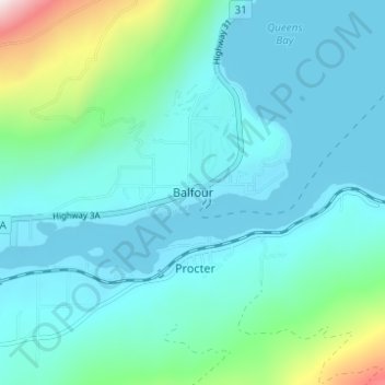
Name: Balfour topographic map, elevation, terrain.
Average elevation: 673 m
Minimum elevation: 526 m
Maximum elevation: 1,455 m
Other topographic maps
Click on a map to view its topography, its elevation and its terrain.
West Arm Provincial Park
Canada > British Columbia > Regional District of Central Kootenay > Area E (Balfour/Cottonwood Lake)
West Arm Provincial Park, Area E (Balfour/Cottonwood Lake), Regional District of Central Kootenay, British Columbia, Canada
Average elevation: 1,449 m
Granite
Canada > British Columbia > Regional District of Central Kootenay > Area E (Balfour/Cottonwood Lake) > Blewett
Granite, Blewett, Area E (Balfour/Cottonwood Lake), Regional District of Central Kootenay, British Columbia, V1L 6X4, Canada
Average elevation: 772 m
Ross-White Lady Lake Recreation Site
Canada > British Columbia > Regional District of Central Kootenay > Area E (Balfour/Cottonwood Lake)
Ross-White Lady Lake Recreation Site, Area E (Balfour/Cottonwood Lake), Regional District of Central Kootenay, British Columbia, Canada
Average elevation: 1,858 m
Blewett
Canada > British Columbia > Regional District of Central Kootenay > Area E (Balfour/Cottonwood Lake) > Blewett
Blewett, Area E (Balfour/Cottonwood Lake), Regional District of Central Kootenay, British Columbia, V1L 6X4, Canada
Average elevation: 837 m
Area E (Balfour/Cottonwood Lake)
Canada > British Columbia > Regional District of Central Kootenay > Area E (Balfour/Cottonwood Lake)
Area E (Balfour/Cottonwood Lake), Regional District of Central Kootenay, British Columbia, Canada
Average elevation: 1,433 m
Kokanee Creek Provincial Park
Canada > British Columbia > Regional District of Central Kootenay > Area E (Balfour/Cottonwood Lake)
Kokanee Creek Provincial Park, Area E (Balfour/Cottonwood Lake), Regional District of Central Kootenay, British Columbia, Canada
Average elevation: 617 m
Kokanee Creek
Canada > British Columbia > Regional District of Central Kootenay > Area E (Balfour/Cottonwood Lake)
Kokanee Creek, Area E (Balfour/Cottonwood Lake), Regional District of Central Kootenay, British Columbia, Canada
Average elevation: 2,022 m