
Make a donation
Gear up for your next adventure:
As an Amazon Associate, this site earns from qualifying purchases at no extra cost to you.
Wesley Chapel topographic map
Click on the map to display elevation.
Make a donation
Gear up for your next adventure:
As an Amazon Associate, this site earns from qualifying purchases at no extra cost to you.
Wesley Chapel
According to the United States Census Bureau, the CDP has a total area of 6.1 square miles (16 km2), of which 6.1 square miles (16 km2) is land and 0.04 square miles (0.10 km2) (0.49%) is water. The elevation is about 100 feet (30 m), combined with an inland location, creates more temperature variation in the humid subtropical climate.
Make a donation
Gear up for your next adventure:
As an Amazon Associate, this site earns from qualifying purchases at no extra cost to you.
About this map
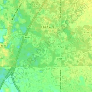
Name: Wesley Chapel topographic map, elevation, terrain.
Location: Wesley Chapel, Pasco County, Florida, United States (28.16993 -82.40338 28.20310 -82.32457)
Average elevation: 19 m
Minimum elevation: 9 m
Maximum elevation: 26 m
Make a donation
Gear up for your next adventure:
As an Amazon Associate, this site earns from qualifying purchases at no extra cost to you.
Other topographic maps
Click on a map to view its topography, its elevation and its terrain.
New Port Richey
United States > Florida > Pasco County
New Port Richey présente un terrain essentiellement plat, caractéristique de la région. L'altitude de la ville oscille généralement autour de 30 pieds (environ 9 mètres) au-dessus du niveau de la mer, contribuant à sa vulnérabilité aux inondations lors de fortes pluies. La zone est parsemée de…
Average elevation: 5 m
Zephyrhills
United States > Florida > Pasco County
Zephyrhills is characterized by its gently rolling topography, which contributes to its picturesque landscape. The area's elevation ranges between approximately 70 and 140 feet above sea level, giving it a distinct relief compared to the flat expanses typical of much of central Florida. This rolling terrain,…
Average elevation: 32 m
Dade City
United States > Florida > Pasco County
Dade City contains gently rolling topography with elevations from 60ft to 100ft.
Average elevation: 33 m
Make a donation
Gear up for your next adventure:
As an Amazon Associate, this site earns from qualifying purchases at no extra cost to you.
San Antonio
United States > Florida > Pasco County
San Antonio has a rolling topography with elevations varying from a low of 110 feet on the western edge of the city to as high as 183 feet on a hill overlooking Lake Jovita on the eastern edge of town.
Average elevation: 44 m
Saint Leo
United States > Florida > Pasco County
St. Leo contains rolling hills with elevations from 100 ft to 180 ft.
Average elevation: 46 m
Make a donation
Gear up for your next adventure:
As an Amazon Associate, this site earns from qualifying purchases at no extra cost to you.
Make a donation
Gear up for your next adventure:
As an Amazon Associate, this site earns from qualifying purchases at no extra cost to you.
Make a donation
Gear up for your next adventure:
As an Amazon Associate, this site earns from qualifying purchases at no extra cost to you.
Make a donation
Gear up for your next adventure:
As an Amazon Associate, this site earns from qualifying purchases at no extra cost to you.
Dade City
United States > Florida > Pasco County
Dade City contains gently rolling topography with elevations from 60 ft to 100 ft.
Average elevation: 33 m
Make a donation
Gear up for your next adventure:
As an Amazon Associate, this site earns from qualifying purchases at no extra cost to you.
Dade City
United States > Florida > Pasco County
Dade City contains gently rolling topography with elevations from 60 ft to 100 ft.
Average elevation: 33 m
Make a donation
Gear up for your next adventure:
As an Amazon Associate, this site earns from qualifying purchases at no extra cost to you.
Saint Leo
United States > Florida > Pasco County
St. Leo contains rolling hills with elevations from 100 ft to 180 ft.
Average elevation: 46 m
Make a donation
Gear up for your next adventure:
As an Amazon Associate, this site earns from qualifying purchases at no extra cost to you.
Make a donation
Gear up for your next adventure:
As an Amazon Associate, this site earns from qualifying purchases at no extra cost to you.
San Antonio
United States > Florida > Pasco County
San Antonio has a rolling topography with elevations varying from a low of 110 feet on the western edge of the city to as high as 183 feet on a hill overlooking Lake Jovita on the eastern edge of town.
Average elevation: 44 m
Make a donation
Gear up for your next adventure:
As an Amazon Associate, this site earns from qualifying purchases at no extra cost to you.
Dade City
United States > Florida > Pasco County
Dade City contains gently rolling topography with elevations from 60ft to 100ft.
Average elevation: 33 m
Make a donation
Gear up for your next adventure:
As an Amazon Associate, this site earns from qualifying purchases at no extra cost to you.