Geolocate

Hudson topographic map

Click on the map to display elevation.

About this map

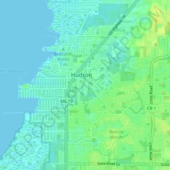
Name: Hudson topographic map, elevation, terrain.

Location: Hudson, Pasco County, Florida, 34667, United States (28.33816 -82.72364 28.37833 -82.65768)

Average elevation: 5 m

Minimum elevation: -1 m

Maximum elevation: 15 m

Other topographic maps

Click on a map to view its topography, its elevation and its terrain.

Hudson

United States > Florida > Pasco County > Hudson

Average elevation: 5 m

Gear up for your next adventure:

🧤Rechargeable Heated Gloves - Extreme warmth for Canadian winter expeditions
🌬️Windproof Camp Stove - Efficient cooking even on exposed mountain peaks
🥘Camping Cookware Set - Compact nesting pots and pans for trail cooking
🛌Insulated Sleeping Pad - Critical thermal barrier between you and the cold ground
🚑Survival Whistle - Signal for help across long distances in mountains

As an Amazon Associate, this site earns from qualifying purchases at no extra cost to you.