Geolocate

Zephyrhills topographic map

Click on the map to display elevation.

Zephyrhills

Zephyrhills is known for its rolling topography, hence the name.

Wikipedia (CC-BY-SA 3.0)

About this map

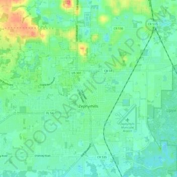
Name: Zephyrhills topographic map, elevation, terrain.

Location: Zephyrhills, Pasco County, Florida, 33542, United States (28.19696 -82.24174 28.28826 -82.14495)

Average elevation: 32 m

Minimum elevation: 17 m

Maximum elevation: 71 m

Other topographic maps

Click on a map to view its topography, its elevation and its terrain.

River Ridge

United States > Florida > Pasco County

Average elevation: 11 m

Gulf Harbors

United States > Florida > Pasco County > Elfers

Average elevation: 1 m

Fivay Junction

United States > Florida > Pasco County

Average elevation: 21 m

Bayonet Point

United States > Florida > Pasco County

Average elevation: 7 m

Holiday

United States > Florida > Pasco County

Average elevation: 5 m

Elfers

United States > Florida > Pasco County

Average elevation: 5 m

Forest Hills

United States > Florida > Pasco County > Holiday

Average elevation: 4 m

Gear up for your next adventure:

🛶Kayak Accessories - Essential gear for safe and fun kayaking adventures
🐕Hiking Dog Pack - Let your canine companion carry their own water and food
Camping Essentials - All-in-one gear for a comfortable camping trip
🎒Hiking Daypack - Lightweight and durable backpacks for day trips and excursions
🥾Light Trekking Boots - Supportive boots for multi-day treks

As an Amazon Associate, this site earns from qualifying purchases at no extra cost to you.