Geolocate

Erie Lake topographic map

Click on the map to display elevation.

About this map

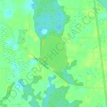
Name: Erie Lake topographic map, elevation, terrain.

Location: Erie Lake, Lake County, Florida, United States (28.47280 -81.85250 28.48213 -81.84497)

Average elevation: 34 m

Minimum elevation: 25 m

Maximum elevation: 43 m

Other topographic maps

Click on a map to view its topography, its elevation and its terrain.

Whitney

United States > Florida > Lake County

Average elevation: 25 m

Royal Highlands

United States > Florida > Lake County

Average elevation: 30 m

Mount Plymouth

United States > Florida > Lake County

Average elevation: 25 m

Jacks Lake

United States > Florida > Lake County > Clermont

Average elevation: 54 m

Lake Louisa

United States > Florida > Lake County

Average elevation: 31 m

Gear up for your next adventure:

🧥Ultralight Puffy Jacket - Maximum warmth that packs down to the size of an orange
🚲Handlebar Phone Mount - View topographic-map.com live while cycling
Tent Footprint - Protect tent floor and increase durability
🛶Kayak Accessories - Essential gear for safe and fun kayaking adventures
🧥Thermal Layer - Insulating layer for cold outdoor conditions

As an Amazon Associate, this site earns from qualifying purchases at no extra cost to you.