
Area F (Columbia Lake/Windermere Lake) topographic map
Interactive map
Click on the map to display elevation.
About this map
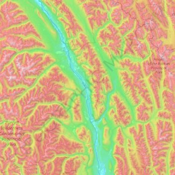
Name: Area F (Columbia Lake/Windermere Lake) topographic map, elevation, terrain.
Average elevation: 1,815 m
Minimum elevation: 775 m
Maximum elevation: 3,425 m
Other topographic maps
Click on a map to view its topography, its elevation and its terrain.
Fairmont Hot Springs
Canada > British Columbia > Regional District of East Kootenay > Area F (Columbia Lake/Windermere Lake)
Fairmont Hot Springs, Area F (Columbia Lake/Windermere Lake), Regional District of East Kootenay, British Columbia, V0B 1L0, Canada
Average elevation: 920 m
Fernie
Canada > British Columbia > Regional District of East Kootenay
Fernie, Regional District of East Kootenay, British Columbia, Canada
Average elevation: 1,141 m
Cranbrook
Canada > British Columbia > Regional District of East Kootenay
Cranbrook, Regional District of East Kootenay, British Columbia, Canada
Average elevation: 991 m
Radium Hot Springs
Canada > British Columbia > Regional District of East Kootenay
Radium Hot Springs, Regional District of East Kootenay, British Columbia, V0A 1M0, Canada
Average elevation: 913 m
Invermere
Canada > British Columbia > Regional District of East Kootenay
Invermere, Regional District of East Kootenay, British Columbia, Canada
Average elevation: 876 m
Upper Elk Lake
Canada > British Columbia > Regional District of East Kootenay > Area A (Upper Flathead/Elk Valley)
Upper Elk Lake, Area A (Upper Flathead/Elk Valley), Regional District of East Kootenay, British Columbia, Canada
Average elevation: 1,982 m
Kimberley
Canada > British Columbia > Regional District of East Kootenay
Kimberley, Regional District of East Kootenay, British Columbia, Canada
Average elevation: 1,216 m
The Nublet
Canada > British Columbia > Regional District of East Kootenay > Area G (Forster Creek/Mount Assiniboine)
The Nublet, Area G (Forster Creek/Mount Assiniboine), Regional District of East Kootenay, British Columbia, Canada
Average elevation: 2,301 m
Wasa Lake
Canada > British Columbia > Regional District of East Kootenay > Area E (Saint Mary/Skookumchuck) > Wasa
Wasa Lake, Wasa, Area E (Saint Mary/Skookumchuck), Regional District of East Kootenay, British Columbia, V0B 2K0, Canada
Average elevation: 793 m
Kootenay National Park
Canada > British Columbia > Regional District of East Kootenay > Area G (Forster Creek/Mount Assiniboine)
Kootenay National Park, Area G (Forster Creek/Mount Assiniboine), Regional District of East Kootenay, British Columbia, Canada
Average elevation: 1,832 m
Barnes Lake
Canada > British Columbia > Regional District of East Kootenay > Area A (Upper Flathead/Elk Valley)
Barnes Lake, Area A (Upper Flathead/Elk Valley), Regional District of East Kootenay, British Columbia, Canada
Average elevation: 2,073 m
Sparwood
Canada > British Columbia > Regional District of East Kootenay
Sparwood, Regional District of East Kootenay, British Columbia, Canada
Average elevation: 1,778 m
Bull Mountain
Canada > British Columbia > Regional District of East Kootenay > Area C (Moyie/Bull River)
Bull Mountain, Area C (Moyie/Bull River), Regional District of East Kootenay, British Columbia, Canada
Average elevation: 2,068 m
Baynes Lake
Canada > British Columbia > Regional District of East Kootenay > Area B (Lake Koocanusa)
Baynes Lake, Area B (Lake Koocanusa), Regional District of East Kootenay, British Columbia, Canada
Average elevation: 796 m
Spillimacheen
Canada > British Columbia > Regional District of East Kootenay > Area G (Forster Creek/Mount Assiniboine)
Spillimacheen, Area G (Forster Creek/Mount Assiniboine), Regional District of East Kootenay, British Columbia, Canada
Average elevation: 971 m
Deer lake
Canada > British Columbia > Regional District of East Kootenay > Area B (Lake Koocanusa)
Deer lake, Area B (Lake Koocanusa), Regional District of East Kootenay, British Columbia, Canada
Average elevation: 811 m
Gold Creek
Canada > British Columbia > Regional District of East Kootenay > Area B (Lake Koocanusa)
Gold Creek, Area B (Lake Koocanusa), Regional District of East Kootenay, British Columbia, Canada
Average elevation: 823 m
Fording River
Canada > British Columbia > Regional District of East Kootenay > Elkford
Fording River, Elkford, Regional District of East Kootenay, British Columbia, Canada
Average elevation: 1,787 m
Jim Smith Lake
Canada > British Columbia > Regional District of East Kootenay > Area C (Moyie/Bull River)
Jim Smith Lake, Area C (Moyie/Bull River), Regional District of East Kootenay, British Columbia, Canada
Average elevation: 1,091 m
Big White Peak
Canada > British Columbia > Regional District of East Kootenay > Area B (Lake Koocanusa)
Big White Peak, Area B (Lake Koocanusa), Regional District of East Kootenay, British Columbia, Canada
Average elevation: 1,860 m
Whiteswan Lake
Canada > British Columbia > Regional District of East Kootenay > Area F (Columbia Lake/Windermere Lake)
Whiteswan Lake, Area F (Columbia Lake/Windermere Lake), Regional District of East Kootenay, British Columbia, Canada
Average elevation: 1,392 m
Moyie Lake
Canada > British Columbia > Regional District of East Kootenay > Area C (Moyie/Bull River) > Moyie
Moyie Lake, Moyie, Area C (Moyie/Bull River), Regional District of East Kootenay, British Columbia, V0B 2A0, Canada
Average elevation: 1,185 m
Maiden Lake
Canada > British Columbia > Regional District of East Kootenay > Fernie
Maiden Lake, Fernie, Regional District of East Kootenay, British Columbia, Canada
Average elevation: 1,045 m
Ta Ta Creek
Canada > British Columbia > Regional District of East Kootenay > Area E (Saint Mary/Skookumchuck)
Ta Ta Creek, Area E (Saint Mary/Skookumchuck), Regional District of East Kootenay, British Columbia, V0B 2K0, Canada
Average elevation: 854 m
Shuswap
Canada > British Columbia > Regional District of East Kootenay > Area F (Columbia Lake/Windermere Lake)
Shuswap, Area F (Columbia Lake/Windermere Lake), Regional District of East Kootenay, British Columbia, V0A 1K3, Canada
Average elevation: 926 m
Elkford
Canada > British Columbia > Regional District of East Kootenay
Elkford, Regional District of East Kootenay, British Columbia, Canada
Average elevation: 1,895 m
Findlay Creek
Canada > British Columbia > Regional District of East Kootenay > Area F (Columbia Lake/Windermere Lake)
Findlay Creek, Area F (Columbia Lake/Windermere Lake), Regional District of East Kootenay, British Columbia, V0B 1B0, Canada
Average elevation: 1,270 m
Wasa Lake Provincial Park
Canada > British Columbia > Regional District of East Kootenay > Area E (Saint Mary/Skookumchuck) > Wasa
Wasa Lake Provincial Park, Wasa, Area E (Saint Mary/Skookumchuck), Regional District of East Kootenay, British Columbia, Canada
Average elevation: 790 m
Redding Creek
Canada > British Columbia > Regional District of East Kootenay > Area E (Saint Mary/Skookumchuck)
Redding Creek, Area E (Saint Mary/Skookumchuck), Regional District of East Kootenay, British Columbia, Canada
Average elevation: 1,762 m
Cobb Lake
Canada > British Columbia > Regional District of East Kootenay > Area G (Forster Creek/Mount Assiniboine)
Cobb Lake, Area G (Forster Creek/Mount Assiniboine), Regional District of East Kootenay, British Columbia, Canada
Average elevation: 1,366 m
Caribou Park
Canada > British Columbia > Regional District of East Kootenay > Elkford
Caribou Park, Elkford, Regional District of East Kootenay, British Columbia, Canada
Average elevation: 1,323 m
Area A (Upper Flathead/Elk Valley)
Canada > British Columbia > Regional District of East Kootenay
Area A (Upper Flathead/Elk Valley), Regional District of East Kootenay, British Columbia, Canada
Average elevation: 1,578 m
Mount Fernie Provincial Park
Canada > British Columbia > Regional District of East Kootenay > Area A (Upper Flathead/Elk Valley)
Mount Fernie Provincial Park, Area A (Upper Flathead/Elk Valley), Regional District of East Kootenay, British Columbia, Canada
Average elevation: 1,108 m
Island Lake
Canada > British Columbia > Regional District of East Kootenay > Area A (Upper Flathead/Elk Valley)
Island Lake, Area A (Upper Flathead/Elk Valley), Regional District of East Kootenay, British Columbia, Canada
Average elevation: 1,511 m
Morrissey Provincial Park
Canada > British Columbia > Regional District of East Kootenay > Area A (Upper Flathead/Elk Valley)
Morrissey Provincial Park, Area A (Upper Flathead/Elk Valley), Regional District of East Kootenay, British Columbia, Canada
Average elevation: 1,040 m
Mount Erickson
Canada > British Columbia > Regional District of East Kootenay > Area A (Upper Flathead/Elk Valley)
Mount Erickson, Area A (Upper Flathead/Elk Valley), Regional District of East Kootenay, British Columbia, Canada
Average elevation: 1,938 m
Fort Steele
Canada > British Columbia > Regional District of East Kootenay > Area C (Moyie/Bull River)
Fort Steele, Area C (Moyie/Bull River), Regional District of East Kootenay, British Columbia, V0B 1N0, Canada
Average elevation: 797 m
Crowsnest Provincial Park
Canada > British Columbia > Regional District of East Kootenay > Sparwood
Crowsnest Provincial Park, Sparwood, Regional District of East Kootenay, British Columbia, Canada
Average elevation: 1,458 m
Elko
Canada > British Columbia > Regional District of East Kootenay > Area B (Lake Koocanusa)
Elko, Area B (Lake Koocanusa), Regional District of East Kootenay, British Columbia, V0B 1J0, Canada
Average elevation: 1,016 m
Fernie
Canada > British Columbia > Regional District of East Kootenay > Fernie
Fernie, Regional District of East Kootenay, British Columbia, V0B 1M0, Canada
Average elevation: 1,551 m
Grizzly Peak
Canada > British Columbia > Regional District of East Kootenay > Area A (Upper Flathead/Elk Valley)
Grizzly Peak, Area A (Upper Flathead/Elk Valley), Regional District of East Kootenay, British Columbia, V0B 1Y0, Canada
Average elevation: 1,962 m
Elkford
Canada > British Columbia > Regional District of East Kootenay > Elkford > Elkford
Elkford, Regional District of East Kootenay, British Columbia, V0B 1Y0, Canada
Average elevation: 1,544 m
Purcell Mountains
Canada > British Columbia > Regional District of East Kootenay > Area G (Forster Creek/Mount Assiniboine)
Purcell Mountains, Area G (Forster Creek/Mount Assiniboine), Regional District of East Kootenay, British Columbia, Canada
Average elevation: 2,710 m
Steeples
Canada > British Columbia > Regional District of East Kootenay > Cranbrook
Steeples, Cranbrook, Regional District of East Kootenay, British Columbia, Canada
Average elevation: 940 m
Kootenay National Park
Canada > British Columbia > Regional District of East Kootenay > Area G (Forster Creek/Mount Assiniboine)
Kootenay National Park, Area G (Forster Creek/Mount Assiniboine), Regional District of East Kootenay, British Columbia, Canada
Average elevation: 1,832 m
Baptiste Lake
Canada > British Columbia > Regional District of East Kootenay > Area G (Forster Creek/Mount Assiniboine)
Baptiste Lake, Area G (Forster Creek/Mount Assiniboine), Regional District of East Kootenay, British Columbia, Canada
Average elevation: 1,067 m
Area C (Moyie/Bull River)
Canada > British Columbia > Regional District of East Kootenay
Area C (Moyie/Bull River), Regional District of East Kootenay, British Columbia, Canada
Average elevation: 1,572 m
Mount Bisaro
Canada > British Columbia > Regional District of East Kootenay > Area C (Moyie/Bull River)
Mount Bisaro, Area C (Moyie/Bull River), Regional District of East Kootenay, British Columbia, Canada
Average elevation: 2,115 m
Edgewater
Canada > British Columbia > Regional District of East Kootenay > Area G (Forster Creek/Mount Assiniboine) > Edgewater
Edgewater, Area G (Forster Creek/Mount Assiniboine), Regional District of East Kootenay, British Columbia, V0A 1E0, Canada
Average elevation: 874 m
Area E (Saint Mary/Skookumchuck)
Canada > British Columbia > Regional District of East Kootenay
Area E (Saint Mary/Skookumchuck), Regional District of East Kootenay, British Columbia, Canada
Average elevation: 1,644 m