
Bull Mountain topographic map
Click on the map to display elevation.
About this map
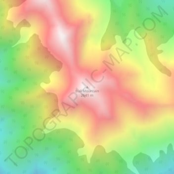
Name: Bull Mountain topographic map, elevation, terrain.
Average elevation: 2,068 m
Minimum elevation: 1,495 m
Maximum elevation: 2,615 m
Regional District of East Kootenay trails, hiking, mountain biking, running and outdoor activities
Other topographic maps
Click on a map to view its topography, its elevation and its terrain.
Moyie Lake
Canada > British Columbia > Regional District of East Kootenay > Area C (Moyie/Bull River) > Moyie
Average elevation: 1,185 m
Monroe Lake
Canada > British Columbia > Regional District of East Kootenay > Area C (Moyie/Bull River)
Average elevation: 1,105 m
Jim Smith Lake
Canada > British Columbia > Regional District of East Kootenay > Area C (Moyie/Bull River)
Average elevation: 1,091 m