
Baynes Lake topographic map
Click on the map to display elevation.
About this map
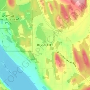
Name: Baynes Lake topographic map, elevation, terrain.
Average elevation: 796 m
Minimum elevation: 734 m
Maximum elevation: 881 m
Regional District of East Kootenay trails, hiking, mountain biking, running and outdoor activities
Other topographic maps
Click on a map to view its topography, its elevation and its terrain.
Deer lake
Canada > British Columbia > Regional District of East Kootenay > Area B (Lake Koocanusa)
Average elevation: 811 m
Kikomun Creek Provincial Park
Canada > British Columbia > Regional District of East Kootenay > Area B (Lake Koocanusa) > Baynes Lake
Average elevation: 782 m
Gold Creek
Canada > British Columbia > Regional District of East Kootenay > Area B (Lake Koocanusa)
Average elevation: 823 m