
Make a donation
Gear up for your next adventure:
As an Amazon Associate, this site earns from qualifying purchases at no extra cost to you.
Malmerspach topographic map
Click on the map to display elevation.
Make a donation
Gear up for your next adventure:
As an Amazon Associate, this site earns from qualifying purchases at no extra cost to you.
About this map
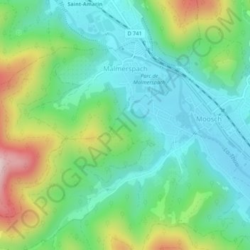
Name: Malmerspach topographic map, elevation, terrain.
Average elevation: 502 m
Minimum elevation: 380 m
Maximum elevation: 790 m
Make a donation
Gear up for your next adventure:
As an Amazon Associate, this site earns from qualifying purchases at no extra cost to you.
Other topographic maps
Click on a map to view its topography, its elevation and its terrain.
Ballon d'Alsace
France > Grand Est > Haut-Rhin > Sewen
Le ballon d'Alsace, qui culmine à 1 247 mètres d'altitude, est l'un des premiers sommets significatifs lorsqu'on aborde le massif des Vosges par le sud. Il offre ainsi un large panorama, la Forêt-Noire à l'est, le Jura, la trouée de Belfort et, par temps clair, la chaîne des Alpes bernoises et le mont…
Average elevation: 994 m
Petit Ballon
France > Grand Est > Haut-Rhin > Linthal
Le Petit Ballon (Kahler Wasen ou Kleiner Belchen en allemand) est un sommet secondaire du massif des Vosges situé dans le département du Haut-Rhin (Grand Est). Il culmine à 1 272 mètres d'altitude. Son sommet donne un point de vue panoramique, marqué par une statue de la Vierge et une antenne-relais…
Average elevation: 1,050 m
Make a donation
Gear up for your next adventure:
As an Amazon Associate, this site earns from qualifying purchases at no extra cost to you.
Lac du Forlet
France > Grand Est > Haut-Rhin > Soultzeren
Le lac des Truites, ou lac du Forlet, est le plus élevé des lacs vosgiens à 1 066 m d'altitude. Il est dénommé Forlenweier en alsacien et reïf tou blan en welsch.
Average elevation: 1,134 m
Make a donation
Gear up for your next adventure:
As an Amazon Associate, this site earns from qualifying purchases at no extra cost to you.
Col du Grand Ballon
France > Grand Est > Haut-Rhin > Soultz-Haut-Rhin
La route des Crêtes contourne le sommet par l'est, franchissant un col à l'altitude de 1 341 mètres, entre le Markstein et le Hartmannswillerkopf (Vieil Armand).
Average elevation: 1,143 m
Make a donation
Gear up for your next adventure:
As an Amazon Associate, this site earns from qualifying purchases at no extra cost to you.
Make a donation
Gear up for your next adventure:
As an Amazon Associate, this site earns from qualifying purchases at no extra cost to you.
Make a donation
Gear up for your next adventure:
As an Amazon Associate, this site earns from qualifying purchases at no extra cost to you.
Le Markstein
France > Grand Est > Haut-Rhin > Fellering
Le Markstein est une station de sports d'hiver, d'été et de détente (luge d'été et parapente) française, située dans le massif des Vosges, comprise entre 1 040 et 1 265 m d'altitude sur le passage de la route des Crêtes. Elle forme un ensemble de ski de fond avec le site du Breitfirst et la haute route…
Average elevation: 1,013 m
Make a donation
Gear up for your next adventure:
As an Amazon Associate, this site earns from qualifying purchases at no extra cost to you.
Make a donation
Gear up for your next adventure:
As an Amazon Associate, this site earns from qualifying purchases at no extra cost to you.
Make a donation
Gear up for your next adventure:
As an Amazon Associate, this site earns from qualifying purchases at no extra cost to you.
Make a donation
Gear up for your next adventure:
As an Amazon Associate, this site earns from qualifying purchases at no extra cost to you.
Trouée de Belfort
France > Grand Est > Haut-Rhin > Valdieu-Lutran
Le point le plus haut est le mont Salbert, à 651 m d'altitude. Le point le plus bas est la vallée du Doubs à Montbéliard, à 315 m d'altitude.
Average elevation: 352 m
Make a donation
Gear up for your next adventure:
As an Amazon Associate, this site earns from qualifying purchases at no extra cost to you.
Make a donation
Gear up for your next adventure:
As an Amazon Associate, this site earns from qualifying purchases at no extra cost to you.
Make a donation
Gear up for your next adventure:
As an Amazon Associate, this site earns from qualifying purchases at no extra cost to you.
Make a donation
Gear up for your next adventure:
As an Amazon Associate, this site earns from qualifying purchases at no extra cost to you.
Make a donation
Gear up for your next adventure:
As an Amazon Associate, this site earns from qualifying purchases at no extra cost to you.
Grand Canal d'Alsace
France > Grand Est > Haut-Rhin > Vogelgrun
Le Rhin antérieur est issu de plusieurs sources dans l'Ouest du Surselva et se dirige ensuite vers l'est. L'une de ces sources, située au lac de Toma à 2 345 m d'altitude, est généralement considérée comme la source du Rhin ; le lac s'écoule ensuite dans le Rein da Tuma (de). Le lac de Toma n'est pas…
Average elevation: 192 m
Make a donation
Gear up for your next adventure:
As an Amazon Associate, this site earns from qualifying purchases at no extra cost to you.
Make a donation
Gear up for your next adventure:
As an Amazon Associate, this site earns from qualifying purchases at no extra cost to you.
Kastelberg
France > Grand Est > Haut-Rhin > Metzeral
Le Kastelberg est le quatrième plus haut sommet du massif des Vosges avec 1 350 mètres d'altitude formant l'ancienne limite régionale entre l'Alsace (Haut-Rhin) et la Lorraine (Vosges).
Average elevation: 1,135 m
Make a donation
Gear up for your next adventure:
As an Amazon Associate, this site earns from qualifying purchases at no extra cost to you.
Saint-Pierre-sur-l'Hâte
France > Grand Est > Haut-Rhin > Sainte-Marie-aux-Mines
Average elevation: 662 m
Make a donation
Gear up for your next adventure:
As an Amazon Associate, this site earns from qualifying purchases at no extra cost to you.
Make a donation
Gear up for your next adventure:
As an Amazon Associate, this site earns from qualifying purchases at no extra cost to you.
Make a donation
Gear up for your next adventure:
As an Amazon Associate, this site earns from qualifying purchases at no extra cost to you.
Make a donation
Gear up for your next adventure:
As an Amazon Associate, this site earns from qualifying purchases at no extra cost to you.
Make a donation
Gear up for your next adventure:
As an Amazon Associate, this site earns from qualifying purchases at no extra cost to you.
Grand Ballon
France > Grand Est > Haut-Rhin > Goldbach-Altenbach
La route des Crêtes contourne le sommet par l'est, franchissant un col à l'altitude de 1 341 mètres, entre le Markstein et le Hartmannswillerkopf (Vieil Armand).
Average elevation: 1,139 m
Make a donation
Gear up for your next adventure:
As an Amazon Associate, this site earns from qualifying purchases at no extra cost to you.
Lac des Perches
France > Grand Est > Haut-Rhin > Rimbach-près-Masevaux
Le lac des Perches ou lac des Bers est un petit lac du versant alsacien des Vosges dans le fond de la vallée de Masevaux, sur le territoire de la commune de Rimbach-près-Masevaux. Il se situe dans un ancien cirque granitique d'origine glaciaire au pied de la Tête des Perches à 1 222 m d'altitude et à…
Average elevation: 993 m
Make a donation
Gear up for your next adventure:
As an Amazon Associate, this site earns from qualifying purchases at no extra cost to you.
Make a donation
Gear up for your next adventure:
As an Amazon Associate, this site earns from qualifying purchases at no extra cost to you.