
Thank you for supporting this site ❤️
Make a donation
Make a donation
Gear up for your next adventure:
As an Amazon Associate, this site earns from qualifying purchases at no extra cost to you.
Col du Grand Ballon topographic map
Click on the map to display elevation.
Thank you for supporting this site ❤️
Make a donation
Make a donation
Gear up for your next adventure:
As an Amazon Associate, this site earns from qualifying purchases at no extra cost to you.
Col du Grand Ballon
La route des Crêtes contourne le sommet par l'est, franchissant un col à l'altitude de 1 341 mètres, entre le Markstein et le Hartmannswillerkopf (Vieil Armand).
Thank you for supporting this site ❤️
Make a donation
Make a donation
Gear up for your next adventure:
As an Amazon Associate, this site earns from qualifying purchases at no extra cost to you.
About this map
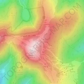
Name: Col du Grand Ballon topographic map, elevation, terrain.
Average elevation: 1,143 m
Minimum elevation: 820 m
Maximum elevation: 1,419 m
Thank you for supporting this site ❤️
Make a donation
Make a donation
Gear up for your next adventure:
As an Amazon Associate, this site earns from qualifying purchases at no extra cost to you.