
Make a donation
Gear up for your next adventure:
As an Amazon Associate, this site earns from qualifying purchases at no extra cost to you.
Île du Rhin topographic map
Click on the map to display elevation.
Make a donation
Gear up for your next adventure:
As an Amazon Associate, this site earns from qualifying purchases at no extra cost to you.
About this map
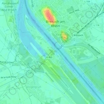
Name: Île du Rhin topographic map, elevation, terrain.
Average elevation: 192 m
Minimum elevation: 181 m
Maximum elevation: 229 m
Make a donation
Gear up for your next adventure:
As an Amazon Associate, this site earns from qualifying purchases at no extra cost to you.
Other topographic maps
Click on a map to view its topography, its elevation and its terrain.
Grand Canal d'Alsace
France > Grand Est > Haut-Rhin > Vogelgrun
Le Rhin antérieur est issu de plusieurs sources dans l'Ouest du Surselva et se dirige ensuite vers l'est. L'une de ces sources, située au lac de Toma à 2 345 m d'altitude, est généralement considérée comme la source du Rhin ; le lac s'écoule ensuite dans le Rein da Tuma (de). Le lac de Toma n'est pas…
Average elevation: 192 m