
Make a donation
Gear up for your next adventure:
As an Amazon Associate, this site earns from qualifying purchases at no extra cost to you.
Petit Ballon topographic map
Click on the map to display elevation.
Make a donation
Gear up for your next adventure:
As an Amazon Associate, this site earns from qualifying purchases at no extra cost to you.
Petit Ballon
Le Petit Ballon (Kahler Wasen ou Kleiner Belchen en allemand) est un sommet secondaire du massif des Vosges situé dans le département du Haut-Rhin (Grand Est). Il culmine à 1 272 mètres d'altitude. Son sommet donne un point de vue panoramique, marqué par une statue de la Vierge et une antenne-relais radio. La route ne permet pas d'accéder directement au sommet mais seulement au col à 1 163 m d'altitude.
Make a donation
Gear up for your next adventure:
As an Amazon Associate, this site earns from qualifying purchases at no extra cost to you.
About this map
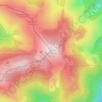
Name: Petit Ballon topographic map, elevation, terrain.
Average elevation: 1,050 m
Minimum elevation: 676 m
Maximum elevation: 1,266 m
Make a donation
Gear up for your next adventure:
As an Amazon Associate, this site earns from qualifying purchases at no extra cost to you.