
Thank you for supporting this site ❤️
Make a donation
Make a donation
Gear up for your next adventure:
As an Amazon Associate, this site earns from qualifying purchases at no extra cost to you.
Londenbach-Gebraech topographic map
Click on the map to display elevation.
Thank you for supporting this site ❤️
Make a donation
Make a donation
Gear up for your next adventure:
As an Amazon Associate, this site earns from qualifying purchases at no extra cost to you.
About this map
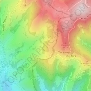
Name: Londenbach-Gebraech topographic map, elevation, terrain.
Average elevation: 733 m
Minimum elevation: 454 m
Maximum elevation: 1,037 m
Thank you for supporting this site ❤️
Make a donation
Make a donation
Gear up for your next adventure:
As an Amazon Associate, this site earns from qualifying purchases at no extra cost to you.
Other topographic maps
Click on a map to view its topography, its elevation and its terrain.
Lac du Forlet
France > Grand Est > Haut-Rhin > Soultzeren
Le lac des Truites, ou lac du Forlet, est le plus élevé des lacs vosgiens à 1 066 m d'altitude. Il est dénommé Forlenweier en alsacien et reïf tou blan en welsch.
Average elevation: 1,134 m