Tyrol topographic map
Interactive map
Click on the map to display elevation.
About this map
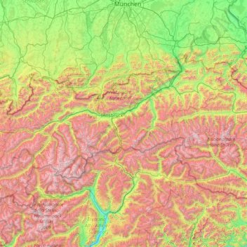
Name: Tyrol topographic map, elevation, terrain.
Location: Tyrol, Austria (46.65136 10.09783 47.74303 12.96600)
Average elevation: 1,410 m
Minimum elevation: 204 m
Maximum elevation: 3,800 m
Other topographic maps
Click on a map to view its topography, its elevation and its terrain.
Lahnberg
Austria > Lower Austria > Bezirk Neunkirchen > Schwarzau im Gebirge
Average elevation: 1,213 m
Vorarlberg
The highest mountain is the Piz Buin, whose rocky peak of 3,312 m (10,866 ft) is surrounded by glaciers. The distance from Lake Constance and the plains of the Alpine Rhine valley across the medium altitude and high Alpine zones to the glaciers of the Silvretta range is a mere 90 km (56 mi).
Average elevation: 1,382 m
Mittersill
Austria > Salzburg > Bezirk Zell am See
It has traffic links running east to west and north to south. The Felbertauern road tunnel runs south through the Hohe Tauern at an elevation of about 1630 m, providing a connection with Lienz in East Tyrol. To the north lies the Thurn Pass at an elevation of 1274 m, providing a connection with Kitzbühel and…
Average elevation: 1,729 m
Klagenfurt Land
Austria > Carinthia > Bezirk Klagenfurt-Land > Krumpendorf am Wörthersee
Average elevation: 894 m
Lake Wörth
Austria > Carinthia > Bezirk Klagenfurt-Land > Schiefling am Wörthersee
Average elevation: 619 m
Graz
Graz is situated on both sides of the Mur river in southeast Austria. It is about 150 km (93 mi) southwest of Vienna (Wien). The nearest larger urban centre is Maribor (Marburg) in Slovenia, which is about 50 km (31 mi) to the south. Graz is the state capital and largest city in Styria, a green and heavily…
Average elevation: 426 m
Stadt Hohenems
The town is located at 432 metres (1,417 feet) above sea level, about 16 km (10 miles) south of Lake Constance. Hohenems extends for 5.5 km (3.4 mi) from north to south and 8.2 km (5.1 mi) from west to east. Its total area is 29 square kilometres (11 sq mi), of which 42% is covered with forest. The oxbow lake…
Average elevation: 660 m
Bad Eisenkappel/Železna Kapla
Austria > Carinthia > Bezirk Völkermarkt > Eisenkappel-Vellach
Average elevation: 914 m
Sölden
Austria > Tyrol > Bezirk Imst
The main village of Sölden is at an elevation of 1,368 metres (4,488 ft) above sea level, and the upper village of Hochsölden at 2,090 m (6,857 ft) has 5 four-star hotels. The highest peak is the Wildspitze, at 3,768 m (12,362 ft), the second highest mountain in Austria, after the Großglockner.
Average elevation: 2,483 m
Hohe Tauern
The best-known mountain pass road of the High Tauern is the scenic Grossglockner High Alpine Road inaugurated in 1935, including a tunnel at an elevation of 2,505 metres (8,219 ft) under the Hochtor Pass (2,573 metres (8,442 ft)). East of it, the Katschberg Pass (1,641 metres (5,384 ft)) on B 99 Katschberg…
Average elevation: 1,492 m