Geolocate

Soboth topographic map

Click on the map to display elevation.

About this map

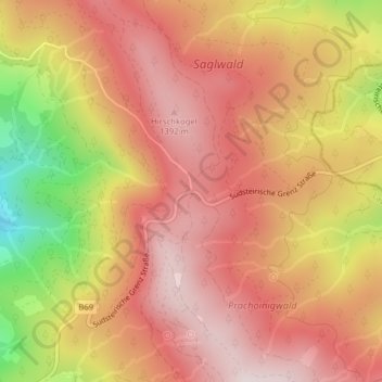
Name: Soboth topographic map, elevation, terrain.

Location: Soboth, Lavamünd, Bezirk Wolfsberg, Carinthia, 9473, Austria (46.66830 15.00993 46.66840 15.01003)

Average elevation: 1,231 m

Minimum elevation: 868 m

Maximum elevation: 1,428 m

Other topographic maps

Click on a map to view its topography, its elevation and its terrain.

Lavamünd

Austria > Carinthia > Bezirk Wolfsberg > Lavamünd

Lavamünd lies in the southeast of Carinthia, close to the border with Slovenia (Slovene Carinthia). It is situated at the confluence of the Lavant and Drava rivers. In the northeast, the Soboth Pass leads across the Koralpe range to Eibiswald in Styria. At an elevation of 348 m (1,142 ft) AA, the area is the…

Average elevation: 768 m

Gear up for your next adventure:

🧭GPS Handheld Device - Reliable GPS navigation for outdoor adventures
🥾Waterproof Trail Shoes - Shoes designed to handle wet terrain
🕶️Polarized Sunglasses - Protect your eyes with durable polarized lenses
🌬️Windproof Camp Stove - Efficient cooking even on exposed mountain peaks
🥾Trail Hiking Socks - Comfortable socks to prevent blisters and fatigue

As an Amazon Associate, this site earns from qualifying purchases at no extra cost to you.