
Make a donation
Gear up for your next adventure:
As an Amazon Associate, this site earns from qualifying purchases at no extra cost to you.
Moon Township topographic map
Click on the map to display elevation.
Make a donation
Gear up for your next adventure:
As an Amazon Associate, this site earns from qualifying purchases at no extra cost to you.
Moon Township
During the Cold War, Moon Township was the location of Nike Site PI-71, which was a battery of Nike Ajax and/or Nike Hercules surface-to-air missiles, used by US armed forces for high – and medium-altitude air defense. The former missile site is now a nature preserve.
Make a donation
Gear up for your next adventure:
As an Amazon Associate, this site earns from qualifying purchases at no extra cost to you.
About this map
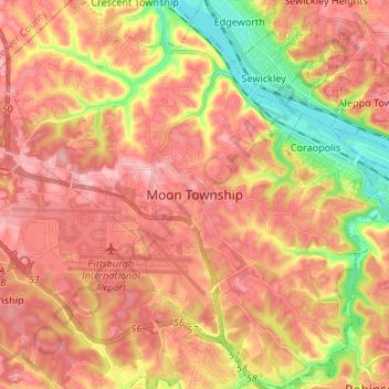
Name: Moon Township topographic map, elevation, terrain.
Location: Moon Township, Allegheny County, Pennsylvania, United States (40.45555 -80.27438 40.55643 -80.14113)
Average elevation: 316 m
Minimum elevation: 206 m
Maximum elevation: 389 m
Make a donation
Gear up for your next adventure:
As an Amazon Associate, this site earns from qualifying purchases at no extra cost to you.
Other topographic maps
Click on a map to view its topography, its elevation and its terrain.
Keown Station
United States > Pennsylvania > Allegheny County > Ross Township
Average elevation: 344 m
Make a donation
Gear up for your next adventure:
As an Amazon Associate, this site earns from qualifying purchases at no extra cost to you.
Champion
United States > Pennsylvania > Allegheny County > North Fayette Township
Average elevation: 360 m
Make a donation
Gear up for your next adventure:
As an Amazon Associate, this site earns from qualifying purchases at no extra cost to you.
Coraopolis Heights
United States > Pennsylvania > Allegheny County > Findlay Township
Average elevation: 320 m
Make a donation
Gear up for your next adventure:
As an Amazon Associate, this site earns from qualifying purchases at no extra cost to you.
Central Highlands
United States > Pennsylvania > Allegheny County > Elizabeth Township
Average elevation: 327 m
Sturgeon
United States > Pennsylvania > Allegheny County > North Fayette Township
Average elevation: 334 m
Make a donation
Gear up for your next adventure:
As an Amazon Associate, this site earns from qualifying purchases at no extra cost to you.
Highland Park Reservoir No. 2
United States > Pennsylvania > Allegheny County > Pittsburgh
Average elevation: 275 m
Make a donation
Gear up for your next adventure:
As an Amazon Associate, this site earns from qualifying purchases at no extra cost to you.
Observatory Hill
United States > Pennsylvania > Allegheny County > Pittsburgh
Average elevation: 319 m
Allegheny River Lock and Dam No. 2
United States > Pennsylvania > Allegheny County > O'Hara Township
Average elevation: 268 m
Make a donation
Gear up for your next adventure:
As an Amazon Associate, this site earns from qualifying purchases at no extra cost to you.
Stoneybrooke Woods
United States > Pennsylvania > Allegheny County > Cheswick
Average elevation: 283 m
Allison Park
United States > Pennsylvania > Allegheny County > Hampton Township
Average elevation: 324 m
Lovedale
United States > Pennsylvania > Allegheny County > Elizabeth Township
Average elevation: 298 m
Make a donation
Gear up for your next adventure:
As an Amazon Associate, this site earns from qualifying purchases at no extra cost to you.
Cochrans Mill
United States > Pennsylvania > Allegheny County > Jefferson Hills
Average elevation: 311 m
Make a donation
Gear up for your next adventure:
As an Amazon Associate, this site earns from qualifying purchases at no extra cost to you.
Neville Island
United States > Pennsylvania > Allegheny County > Neville Township
Average elevation: 289 m
Coverdale
United States > Pennsylvania > Allegheny County > Bethel Park > Coverdale
Average elevation: 354 m
Carnot
United States > Pennsylvania > Allegheny County > Moon Township > Carnot
Average elevation: 336 m
Clinton
United States > Pennsylvania > Allegheny County > Findlay Township > Clinton
Average elevation: 350 m
Make a donation
Gear up for your next adventure:
As an Amazon Associate, this site earns from qualifying purchases at no extra cost to you.
Glenwillard
United States > Pennsylvania > Allegheny County > Crescent Township > Glenwillard
Average elevation: 278 m
Dorseyville
United States > Pennsylvania > Allegheny County > Indiana Township
Average elevation: 325 m