Geolocate

Siwan topographic map

Click on the map to display elevation.

About this map

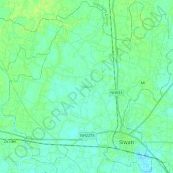
Name: Siwan topographic map, elevation, terrain.

Location: Siwan, Siwan District, Bihar, 841245, India (26.19426 84.24615 26.33202 84.40195)

Average elevation: 65 m

Minimum elevation: 61 m

Maximum elevation: 70 m

Other topographic maps

Click on a map to view its topography, its elevation and its terrain.

Singheswar

India > Bihar > Singheshwar

Average elevation: 47 m

Maheshkhunt

India > Bihar > Gogri

Average elevation: 36 m

Rusera

India > Bihar > Rosera

Average elevation: 45 m

Danapur

India > Bihar > Dinapur-Cum-Khagaul

Average elevation: 52 m

Kuari

India > Bihar > Dhamdaha

Average elevation: 37 m

Runisaidpur

India > Bihar > Runisaidpur

Average elevation: 58 m

Kishanpur

India > Bihar > Kishanpur

Average elevation: 55 m

Mohanpur

India > Bihar > Mohanpur

Average elevation: 122 m

Bhimpur

India > Bihar > Madhepur > Bhimpur

Average elevation: 49 m

Samsa

India > Bihar > Mansurchak > Samsa

Average elevation: 45 m

Raxaul

India > Bihar > Raxaul

Average elevation: 81 m

Gear up for your next adventure:

🔦LED Flashlight - Powerful and long-lasting flashlight for camping and emergencies
🧥Thermal Fleece Jacket - Versatile insulation for changing mountain temperatures
Backpacking Tent - Lightweight tent for long-distance hiking trips
🥾Light Trekking Boots - Supportive boots for multi-day treks
🥾All-Terrain Hiking Boots - Versatile boots for varied hiking conditions

As an Amazon Associate, this site earns from qualifying purchases at no extra cost to you.