Geolocate

Burgundy topographic map

Click on the map to display elevation.

About this map

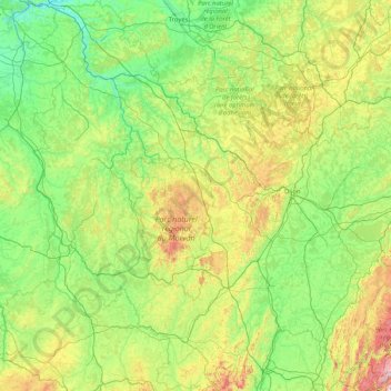
Name: Burgundy topographic map, elevation, terrain.

Location: Burgundy, Metropolitan France, France (46.15601 2.84448 48.40006 5.51887)

Average elevation: 286 m

Minimum elevation: 47 m

Maximum elevation: 1,513 m

Other topographic maps

Click on a map to view its topography, its elevation and its terrain.

Pyrenees

France > Occitania >

In the Western Pyrenees, from the Basque mountains near the Bay of Biscay of the Atlantic Ocean, the average elevation gradually increases from west to east.

Average elevation: 2,716 m

Sermensanne

France > Nouvelle-Aquitaine > Creuse > Saint-Domet

Average elevation: 474 m

Gensac

France > Nouvelle-Aquitaine > Dordogne > Eymet

Average elevation: 85 m

Os

France > New Aquitaine > Os

Average elevation: 105 m

Ballon d'Alsace

France > Grand Est > Haut-Rhin > Sewen

Average elevation: 994 m

Brélévenez

France > Brittany > Côtes-d'Armor > Lannion

Average elevation: 59 m

Fures

France > Auvergne-Rhône-Alpes > Isère

Average elevation: 281 m

Sirach

France > Occitania > Pyrénées-Orientales > Ria-Sirach

Average elevation: 517 m

Pouchon

France > Nouvelle-Aquitaine > Gironde > Mérignac

Average elevation: 41 m

Tregonnour

France > Brittany > Finistère > Fouesnant > Mousterlin

Average elevation: 4 m

La Nauze

France > Occitania > Tarn-et-Garonne > Molières > Molières

Average elevation: 140 m

Les Landes

France > Nouvelle-Aquitaine > Dordogne > Carsac-Aillac

Average elevation: 126 m

Choisy Mount

France > Saint Martin (France)

Average elevation: 20 m

Lidar

France > Auvergne-Rhône-Alpes > Cantal > Brezons

Average elevation: 1,048 m

Quéran

France > Brittany > Finistère > Tréflaouénan

Average elevation: 70 m

Rodon

France > Ile-de-France > Yvelines

Average elevation: 167 m

Prad Don

France > Brittany > Finistère > Plomeur

Average elevation: 26 m

Le Soulier

France > Occitania > Gard > Saint-Martin-de-Valgalgues

Average elevation: 202 m

Argence

France > Auvergne-Rhône-Alpes > Upper Savoy > Habère-Poche

Average elevation: 1,056 m

Choisy Mount

France > Saint Martin (France)

Average elevation: 20 m

Gruchy

France > Normandy > Manche > Blainville-sur-Mer

Average elevation: 19 m

La Bionne

France > Auvergne-Rhône-Alpes > Ain > Brens

Average elevation: 267 m

Bourdials

France > Occitania > Aude > Castans

Average elevation: 745 m

Barre des Écrins

France > Provence-Alpes-Côte d'Azur > Hautes-Alpes > Vallouise-Pelvoux

The Barre des Écrins (French pronunciation: [baʁ dez‿ekʁɛ̃]) is a mountain in the French Alps with a peak elevation of 4,102 metres (13,458 ft). It is the highest peak of the Massif des Écrins and the Dauphiné Alps and the most southerly alpine peak in Europe that is higher than 4,000 metres. It is…

Average elevation: 3,222 m

Axiat

France > Occitania > Ariège > Miglos

Average elevation: 1,038 m

La Montagnerie

France > Brittany > Ille-et-Vilaine > Chauvigné

Average elevation: 74 m

Péraclos

France > Auvergne-Rhône-Alpes > Allier > Chouvigny

Average elevation: 417 m

Montcourt

France > Hauts-de-France > Aisne > Essômes-sur-Marne

Average elevation: 133 m

Comme

France > Grand Est > Meuse > Vigneulles-lès-Hattonchâtel

Average elevation: 307 m

Le Village

France > Centre-Val de Loire > Loiret > Chevannes

Average elevation: 114 m

Gustavia

France > Saint Barthélemy

Average elevation: 14 m

Jardin des Cévennes

France > Ile-de-France > Paris

Average elevation: 43 m

Marigot

France > Saint Martin (France)

Average elevation: 44 m

Meung

France > Bourgogne – Franche-Comté > Nièvre > Pougny

Average elevation: 213 m

La Corderie

France > Normandy > Manche > Saint-Vaast-la-Hougue

Average elevation: 2 m

Hautvilliers

France > Ile-de-France > Yvelines > Chevreuse

Average elevation: 127 m

Pic Saint-Loup

France > Occitania > Hérault > Cazevieille

Average elevation: 276 m

Tour

France > Auvergne-Rhône-Alpes > Loire > Cherier

Average elevation: 787 m

la Croix

France > Occitania > Gard > Argilliers > Argilliers

Average elevation: 91 m

la Pouillargues

France > Nouvelle-Aquitaine > Charente > Juignac

Average elevation: 143 m

Metzing

France > Grand Est > Moselle > Riche

Average elevation: 236 m

Les Allots

France > Centre-Val de Loire > Loiret > Sandillon

Average elevation: 100 m

Parc des Buttes Chaumont

France > Ile-de-France > Paris

Average elevation: 73 m

La Garde de Dieu

France > Centre-Val de Loire > Cher > Culan

Average elevation: 276 m

Falkenstein Castle

France > Grand Est > Moselle > Philippsbourg

In 1981, the Vosges Club (club vosgien) in Strasbourg placed a marker at the castle summit showing the altitude and directions to nearby land features.

Average elevation: 269 m

Mont Blanc / Monte Bianco

France > Auvergne-Rhône-Alpes > Upper Savoy > Saint-Gervais-les-Bains

The climate is cold and temperate (Köppen climate classification Cfb), and is greatly influenced by altitude. Being the highest part of the Alps, Mont Blanc and surrounding mountains can create their own weather patterns. Temperatures drop as the mountains gain in height, and the summit of Mont Blanc is a…

Average elevation: 4,092 m

Tuo

France > Loyalty Islands Province > Maré

Average elevation: 73 m

Les Boudeaux

France > Auvergne-Rhône-Alpes > Allier > Le Pin

Average elevation: 282 m

Val Thorens

France > Auvergne-Rhône-Alpes > Savoy

Val Thorens ([val tɔʁɑ̃]) is a ski town in the Tarentaise Valley in the French Alps at an altitude of 2,300 m (7,500 ft). It is located in the commune of Saint-Martin-de-Belleville in the Savoie department. The resort forms part of the Les Trois Vallées ski area which, with over 600 km of slopes, is one…

Average elevation: 2,516 m

Kerivoas

France > Brittany > Finistère > Guipavas

Average elevation: 73 m

Satel

France > Grand Est > Meuse > Apremont-la-Forêt

Average elevation: 275 m

Ceyrac

France > Occitania > Aveyron > Gabriac

Average elevation: 595 m

Seruch

France > Nouvelle-Aquitaine > Corrèze > Lostanges

Average elevation: 458 m

Campine

France > Auvergne-Rhône-Alpes > Puy-de-Dôme > Brousse

Average elevation: 642 m

Mont Blanc / Monte Bianco

France > Auvergne-Rhône-Alpes > Upper Savoy > Saint-Gervais-les-Bains

The climate is cold and temperate (Köppen climate classification Cfb), and is greatly influenced by altitude. Being the highest part of the Alps, Mont Blanc and surrounding mountains can create their own weather patterns. Temperatures drop as the mountains gain in height, and the summit of Mont Blanc is a…

Average elevation: 4,092 m

Pen Ines

France > Brittany > Morbihan > Locoal-Mendon

Average elevation: 2 m

Mont Blanc / Monte Bianco

France > Auvergne-Rhône-Alpes > Upper Savoy > Saint-Gervais-les-Bains

The climate is cold and temperate (Köppen climate classification Cfb), and is greatly influenced by altitude. Being the highest part of the Alps, Mont Blanc and surrounding mountains can create their own weather patterns. Temperatures drop as the mountains gain in height, and the summit of Mont Blanc is a…

Average elevation: 4,092 m

La Ville

France > Auvergne-Rhône-Alpes > Upper Savoy > Usinens

Average elevation: 414 m

Morel

France > Auvergne-Rhône-Alpes > Savoy > Les Allues

Average elevation: 1,679 m

Pech d'Aspe

France > Occitania > Aude > Mas-des-Cours

Average elevation: 349 m

Les Larges

France > Nouvelle-Aquitaine > Haute-Vienne > Limoges

Average elevation: 353 m

Gear up for your next adventure:

💡Portable Camping Lamp - Rechargeable lamp for campsite lighting
🧢Outdoor Visor - Breathable visor for sunny hikes
🧭Orienteering Kit - Tools for map reading and navigation in the wild
🚲Heavy Duty Bike Lock - Secure your bike at the trailhead or during stops
🔦LED Headlamp - Hands-free lighting for early morning starts or late finishes

As an Amazon Associate, this site earns from qualifying purchases at no extra cost to you.