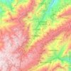
Bolivar State topographic map
Click on the map to display elevation.
Bolivar State
The Tepuis are located mainly in the center and south of the structure. The average altitude is 400 metres or 1,310 feet, with a generalized south–north slope. The highest plateaus exceed 2,000 metres or 6,600 feet. The highest point is Mount Roraima (2,875 metres or 9,432 feet), located in the Pacaraima Range, which continues south with those of Parima and Tapirapeco. The north of the massif is quite homogeneous, with heights below 400 m and numerous witness hills. In the northeast, the Nuria and Imataca mountains stand out, as well as plateaus and hills over 500 metres or 1,640 feet high drained by the Yuruari River. The southeast sector is separated from the northwest sector by the Erebato River and the upper Ventuari Valley. It comprises the Great Savannah and the rest of the territory west of the Caroni River, made up of three high plateaus. The southwest of the massif is made up of lowlands through which the Ventuari, Alto Río Negro and Alto Orinoco rivers flow, with flat topography interrupted by witness hills.
About this map
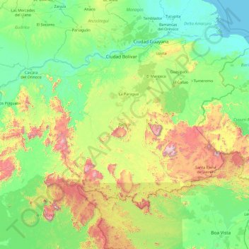
Name: Bolivar State topographic map, elevation, terrain.
Location: Bolivar State, Venezuela (3.60977 -67.44161 8.45945 -60.24212)
Average elevation: 346 m
Minimum elevation: -1 m
Maximum elevation: 2,790 m
Other topographic maps
Click on a map to view its topography, its elevation and its terrain.

Barquisimeto
Venezuela > Lara State > Municipio Iribarren
Barquisimeto is built on the terrace of the same name, on the banks of the Turbio River, about 600 meters (~2000 feet) above sea level, gradually sloping from 520 metres (1,710 feet) in the eastern part of the city to 700 metres (2,300 feet) in the west. As the city lies at the northern edge of the Andes, it…
Average elevation: 649 m

Barquisimeto
Venezuela > Lara State > Municipio Iribarren
Barquisimeto is built on the terrace of the same name, on the banks of the Turbio River, about 600 meters (~2000 feet) above sea level, gradually sloping from 520 metres (1,710 feet) in the eastern part of the city to 700 metres (2,300 feet) in the west. As the city lies at the northern edge of the Andes, it…
Average elevation: 649 m
Cabudare
Venezuela > Lara State > Municipio Palavecino
Cabudare (Spanish pronunciation: [kaβuˈðaɾe], original indigenous name Kabudari), is a city in Lara State, in Venezuela, and capital of the Palavecino Municipality. Located at an elevation of 400 m on the Turbio River, it is on the major west-central freeway, the Autopista Centro Occidental. Due to the…
Average elevation: 637 m

Cueva del Guácharo
Venezuela > Monagas State > Municipio Caripe > La Laguna > Corral Viejo
Average elevation: 1,319 m


Guiana Highlands
Venezuela > Bolivar State > Municipio Angostura
The Guiana Shield (French: Plateau des Guyanes, Bouclier guyanais; Dutch: Hoogland van Guyana, Guianaschild; Portuguese: Planalto das Guianas, Escudo das Guianas; Spanish: Escudo guayanés) is one of the three cratons of the South American Plate. It is a 1.7 billion-year-old Precambrian geological formation in…
Average elevation: 524 m

Mérida
Venezuela > Merida State > Municipio Libertador
This city sits on a plateau nestled in the valley of the Chama River, which runs from end to end. The town of Mérida is located at an altitude of 1,600 metres (5,200 feet). As background on the horizon rises the country's highest summit: the Pico Bolívar with an altitude of 4,981 metres (16,342 feet).
Average elevation: 2,660 m
Valencia
Venezuela > Carabobo State > Municipio Valencia
The elevation of the city is 520 metres (1,710 feet).
Average elevation: 534 m

Cerro Delgado Chalbaud
Venezuela > Amazonas State > Municipio Autónomo Alto Orinoco
Average elevation: 932 m
Mérida
Venezuela > Merida State > Municipio Libertador
This city sits on a plateau nestled in the valley of the Chama River, which runs from end to end. The town of Mérida is located at an altitude of 1,600 metres (5,200 feet). As background on the horizon rises the country's highest summit: the Pico Bolívar with an altitude of 4,981 metres (16,342 feet).
Average elevation: 2,660 m


Valencia
Venezuela > Carabobo State > Municipio Valencia
The elevation of the city is 520 metres (1,710 feet).
Average elevation: 600 m

Cerro Sarisariñama
Venezuela > Bolivar State > Municipio Sucre
Cerro Sarisariñama is a tepui, a flat-topped mountain in Jaua-Sarisariñama National Park at the far south-west of Bolívar State, Venezuela, near the border with Brazil. Its altitude range is between 300 m (980 ft) and 2,350 m (7,710 ft). The name of the mountain originates from the tale of the local…
Average elevation: 1,297 m




San Fernando de Apure
Venezuela > Apure State > Municipio San Fernando
The relief of San Fernando is totally a plain. Natural land elevations do not exist, and the visibility of the horizon can reach up to 10 km. Some high barriers can be artificially by engineer installations for the prevention of floods. The city is established on humid grounds, and for this reason civil…
Average elevation: 45 m

Mérida
Venezuela > Merida State > Municipio Libertador
This city sits on a plateau nestled in the valley of the Chama River, which runs from end to end. The town of Mérida is located at an altitude of 1,600 metres (5,200 feet). As background on the horizon rises the country's highest summit: the Pico Bolívar with an altitude of 4,981 metres (16,342 feet).
Average elevation: 2,660 m
San Fernando de Apure
Venezuela > Apure State > Municipio San Fernando
The relief of San Fernando is totally a plain. Natural land elevations do not exist, and the visibility of the horizon can reach up to 10 km. Some high barriers can be artificially by engineer installations for the prevention of floods. The city is established on humid grounds, and for this reason civil…
Average elevation: 45 m