
Make a donation
Gear up for your next adventure:
As an Amazon Associate, this site earns from qualifying purchases at no extra cost to you.
El Sur topographic map
Click on the map to display elevation.
Make a donation
Gear up for your next adventure:
As an Amazon Associate, this site earns from qualifying purchases at no extra cost to you.
About this map
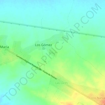
Name: El Sur topographic map, elevation, terrain.
Average elevation: 15 m
Minimum elevation: 1 m
Maximum elevation: 43 m
Make a donation
Gear up for your next adventure:
As an Amazon Associate, this site earns from qualifying purchases at no extra cost to you.
Other topographic maps
Click on a map to view its topography, its elevation and its terrain.
Cubagua Island
Venezuela > Nueva Esparta State > Municipio Tubores
The island is 9.2 by 3.6 km (5.7 by 2.2 mi) in size, an elliptical shape with the longer axis east-west. Its area is 22.438 km2 (9 sq mi). The coast consists of some beaches as well as cliffs from 5 to 7 metres (16 to 23 ft) high in the south and from 20 to 24 metres (66 to 79 ft) high in the north. The…
Average elevation: 6 m