
Make a donation
Gear up for your next adventure:
As an Amazon Associate, this site earns from qualifying purchases at no extra cost to you.
San Fernando de Apure topographic map
Click on the map to display elevation.
Make a donation
Gear up for your next adventure:
As an Amazon Associate, this site earns from qualifying purchases at no extra cost to you.
San Fernando de Apure
The relief of San Fernando is totally a plain. Natural land elevations do not exist, and the visibility of the horizon can reach up to 10 km. Some high barriers can be artificially by engineer installations for the prevention of floods. The city is established on humid grounds, and for this reason civil constructions superior to 5 levels are not permitted. In this sense, San Fernando projects a flat skyline. San Fernando de Apure is a near-exact antipode to the city of Batu, Indonesia.
Make a donation
Gear up for your next adventure:
As an Amazon Associate, this site earns from qualifying purchases at no extra cost to you.
About this map
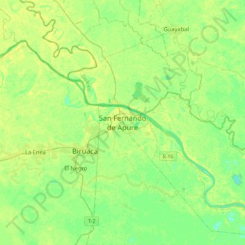
Name: San Fernando de Apure topographic map, elevation, terrain.
Average elevation: 45 m
Minimum elevation: 37 m
Maximum elevation: 57 m
Make a donation
Gear up for your next adventure:
As an Amazon Associate, this site earns from qualifying purchases at no extra cost to you.