
Mérida topographic map
Click on the map to display elevation.
Mérida
This city sits on a plateau nestled in the valley of the Chama River, which runs from end to end. The town of Mérida is located at an altitude of 1,600 metres (5,200 feet). As background on the horizon rises the country's highest summit: the Pico Bolívar with an altitude of 4,981 metres (16,342 feet).
About this map
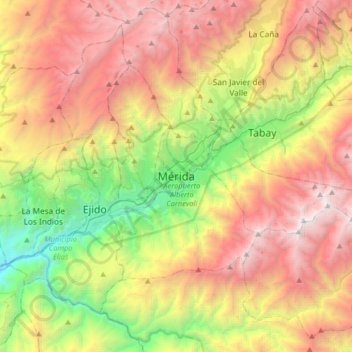
Name: Mérida topographic map, elevation, terrain.
Average elevation: 2,660 m
Minimum elevation: 746 m
Maximum elevation: 4,884 m
Other topographic maps
Click on a map to view its topography, its elevation and its terrain.
Parroquia Mariano Picon Salas
Venezuela > Merida State > Municipio Libertador
Average elevation: 1,780 m