
Make a donation
Gear up for your next adventure:
As an Amazon Associate, this site earns from qualifying purchases at no extra cost to you.
Mühlen topographic map
Click on the map to display elevation.
Make a donation
Gear up for your next adventure:
As an Amazon Associate, this site earns from qualifying purchases at no extra cost to you.
About this map
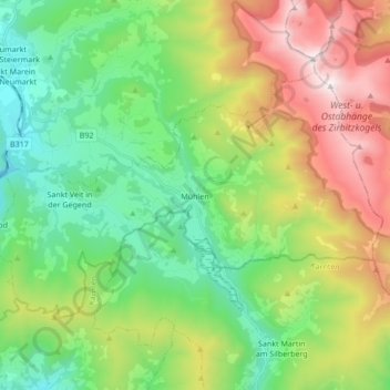
Name: Mühlen topographic map, elevation, terrain.
Location: Mühlen, Bezirk Murau, Styria, 8822, Austria (46.99448 14.41952 47.06792 14.58995)
Average elevation: 1,330 m
Minimum elevation: 771 m
Maximum elevation: 2,383 m
Make a donation
Gear up for your next adventure:
As an Amazon Associate, this site earns from qualifying purchases at no extra cost to you.
Other topographic maps
Click on a map to view its topography, its elevation and its terrain.
Make a donation
Gear up for your next adventure:
As an Amazon Associate, this site earns from qualifying purchases at no extra cost to you.
Make a donation
Gear up for your next adventure:
As an Amazon Associate, this site earns from qualifying purchases at no extra cost to you.
Make a donation
Gear up for your next adventure:
As an Amazon Associate, this site earns from qualifying purchases at no extra cost to you.
Sankt Ruprecht ob Murau
Austria > Styria > Bezirk Murau > Sankt Georgen am Kreischberg
Average elevation: 1,204 m