Geolocate

Rinegg topographic map

Click on the map to display elevation.

About this map

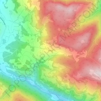
Name: Rinegg topographic map, elevation, terrain.

Location: Rinegg, Ranten, Bezirk Murau, Styria, 8853, Austria (47.13592 14.12400 47.17592 14.16400)

Average elevation: 1,196 m

Minimum elevation: 854 m

Maximum elevation: 1,542 m

Gear up for your next adventure:

🪑Ultralight Camping Stool - Compact seating for rest stops during long hikes
🧦Merino Wool Socks - Moisture-wicking comfort for long-distance hiking
🌡️Emergency Mylar Blankets - Compact thermal protection for unexpected nights outdoors
🥾Waterproof Trail Shoes - Shoes designed to handle wet terrain
🧊Insulated Water Bottle - Keeps drinks cold in summer and prevents freezing in winter

As an Amazon Associate, this site earns from qualifying purchases at no extra cost to you.