Geolocate

Adendorf topographic map

Click on the map to display elevation.

About this map

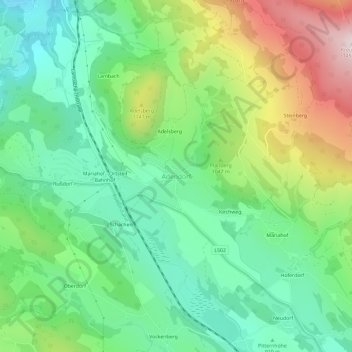
Name: Adendorf topographic map, elevation, terrain.

Location: Adendorf, Neumarkt in der Steiermark, Bezirk Murau, Styria, 8820, Austria (47.08601 14.36393 47.12601 14.40393)

Average elevation: 1,003 m

Minimum elevation: 773 m

Maximum elevation: 1,449 m

Other topographic maps

Click on a map to view its topography, its elevation and its terrain.

Oberwölz

Austria > Styria > Bezirk Murau

Average elevation: 1,464 m

Mühlen

Austria > Styria > Bezirk Murau

Average elevation: 1,330 m

Ranten

Austria > Styria > Bezirk Murau

Average elevation: 1,347 m

Gear up for your next adventure:

🐕Hiking Dog Pack - Let your canine companion carry their own water and food
🧣Merino Neck Gaiter - Protects against wind, sun, and cold at high altitudes
🧭Orienteering Kit - Tools for map reading and navigation in the wild
🔋Solar Power Bank - Keep your GPS and devices charged during long outdoor trips
🧥Fleece Jacket - Warm and lightweight jacket for layering

As an Amazon Associate, this site earns from qualifying purchases at no extra cost to you.