
Massif du Hochschwab topographic map
Interactive map
Click on the map to display elevation.
About this map
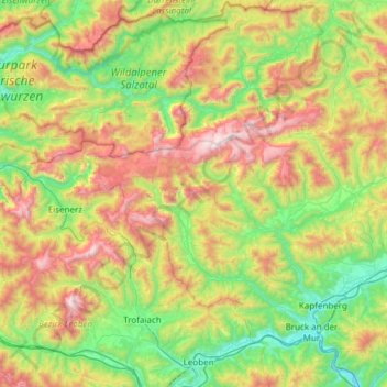
Name: Massif du Hochschwab topographic map, elevation, terrain.
Location: Massif du Hochschwab, Styrie, Autriche (47.37538 14.72704 47.74228 15.33311)
Average elevation: 1,072 m
Minimum elevation: 452 m
Maximum elevation: 2,256 m
Other topographic maps
Click on a map to view its topography, its elevation and its terrain.
Mürzzuschlag
Autriche > Styrie > Bezirk Bruck-Mürzzuschlag
Mürzzuschlag, Bezirk Bruck-Mürzzuschlag, Styrie, 8680, Autriche
Average elevation: 979 m
Riegersburg
Autriche > Styrie > Bezirk Südoststeiermark
Riegersburg, Bezirk Südoststeiermark, Styrie, Autriche
Average elevation: 322 m
Lainbach
Autriche > Styrie > Bezirk Liezen > Landl
Lainbach, Landl, Bezirk Liezen, Styrie, 8931, Autriche
Average elevation: 720 m
Aschau
Autriche > Styrie > Bezirk Weiz > Fladnitz an der Teichalm
Aschau, Fladnitz an der Teichalm, Bezirk Weiz, Styrie, 8163, Autriche
Average elevation: 885 m
Dreihöfen
Autriche > Styrie > Bezirk Graz-Umgebung > Semriach
Dreihöfen, Semriach, Bezirk Graz-Umgebung, Styrie, 8102, Autriche
Average elevation: 849 m
Mixnitz
Autriche > Styrie > Bezirk Bruck-Mürzzuschlag
Mixnitz, Pernegg an der Mur, Bezirk Bruck-Mürzzuschlag, Styrie, 8131, Autriche
Average elevation: 680 m
Passail
Autriche > Styrie > Bezirk Weiz
Passail, Bezirk Weiz, Styrie, 8162, Autriche
Average elevation: 875 m
Burgau
Autriche > Styrie > Bezirk Hartberg-Fürstenfeld
Burgau, Bezirk Hartberg-Fürstenfeld, Styrie, 8291, Autriche
Average elevation: 299 m
Gemeinde Spital am Semmering
Autriche > Styrie > Bezirk Bruck-Mürzzuschlag
Gemeinde Spital am Semmering, Bezirk Bruck-Mürzzuschlag, Styrie, 8684, Autriche
Average elevation: 1,158 m
Altaussee
Autriche > Styrie > Bezirk Liezen > Altaussee
Altaussee, Bezirk Liezen, Styrie, 8992, Autriche
Average elevation: 1,199 m
Garges
Autriche > Styrie > Bezirk Murtal > Unzmarkt-Frauenburg
Garges, Unzmarkt-Frauenburg, Bezirk Murtal, Styrie, 8800, Autriche
Average elevation: 1,069 m
Unterlamm
Autriche > Styrie > Bezirk Südoststeiermark > Unterlamm
Unterlamm, Bezirk Südoststeiermark, Styrie, 8352, Autriche
Average elevation: 313 m
Tollinggraben
Autriche > Styrie > Bezirk Leoben > St. Peter-Freienstein > Tollinggraben
Tollinggraben, St. Peter-Freienstein, Bezirk Leoben, Styrie, 8792, Autriche
Average elevation: 810 m
Neubrennten
Autriche > Styrie > Bezirk Hartberg-Fürstenfeld > Bad Loipersdorf > Neubrennten
Neubrennten, Bad Loipersdorf, Bezirk Hartberg-Fürstenfeld, Styrie, 8282, Autriche
Average elevation: 302 m
Tulwitzdorf
Autriche > Styrie > Bezirk Weiz > Tulwitz
Tulwitzdorf, Tulwitz, Fladnitz an der Teichalm, Bezirk Weiz, Styrie, 8163, Autriche
Average elevation: 721 m
Teichalm
Autriche > Styrie > Bezirk Weiz > Fladnitz an der Teichalm > Teichalm
Teichalm, Fladnitz an der Teichalm, Bezirk Weiz, Styrie, 8163, Autriche
Average elevation: 1,217 m
Weiz
Autriche > Styrie > Bezirk Weiz > Weiz
Weiz, Bezirk Weiz, Styrie, 8160, Autriche
Average elevation: 505 m
Bad Radkersburg
Autriche > Styrie > Bezirk Südoststeiermark > Bad Radkersburg
Bad Radkersburg, Bezirk Südoststeiermark, Styrie, 8490, Autriche
Average elevation: 221 m
Sankt Lambrecht
Autriche > Styrie > Sankt Lambrecht
Sankt Lambrecht, Bezirk Murau, Styrie, 8813, Autriche
Average elevation: 1,251 m
Knittelfeld
Autriche > Styrie > Bezirk Murtal > Knittelfeld > Knittelfeld
Knittelfeld, Bezirk Murtal, Styrie, 8720, Autriche
Average elevation: 741 m
Felberg
Autriche > Styrie > Bezirk Murau > Sankt Lambrecht > Felberg
Felberg, Sankt Lambrecht, Bezirk Murau, Styrie, 8813, Autriche
Average elevation: 1,055 m
Weißkirchen in Steiermark
Autriche > Styrie > Weißkirchen in Steiermark
Weißkirchen in Steiermark, Bezirk Murtal, Styrie, 8741, Autriche
Average elevation: 1,054 m
Naas
Autriche > Styrie > Bezirk Weiz > Naas
Naas, Bezirk Weiz, Styrie, 8160, Autriche
Average elevation: 745 m
Hartberg
Autriche > Styrie > Bezirk Hartberg-Fürstenfeld
Hartberg, Bezirk Hartberg-Fürstenfeld, Styrie, 8230, Autriche
Average elevation: 409 m
Grüner See
Autriche > Styrie > Tragöß-Sankt Katharein
Grüner See, Tragöß-Sankt Katharein, Bezirk Bruck-Mürzzuschlag, Styrie, Autriche
Average elevation: 1,068 m
Anger
Autriche > Styrie > Bezirk Weiz
Anger, Bezirk Weiz, Styrie, 8184, Autriche
Average elevation: 790 m
Weng im Gesäuse
Autriche > Styrie > Weng im Gesäuse
Weng im Gesäuse, Bezirk Liezen, Styrie, 8913, Autriche
Average elevation: 780 m
Reiteralm
Autriche > Styrie > Rottenmann
Reiteralm, Rottenmann, Liezen, Styrie, 8786, Autriche
Average elevation: 1,813 m
Massif mort
Massif mort, Grundlsee, Liezen, Styrie, 8993, Autriche
Average elevation: 1,124 m
Pölling
Autriche > Styrie > Kirchbach-Zerlach
Pölling, Kirchbach-Zerlach, Südoststeiermark, Styrie, 8082, Autriche
Average elevation: 361 m
Jochspitze
Autriche > Styrie > Irdning-Donnersbachtal
Jochspitze, Irdning-Donnersbachtal, Liezen, Styrie, 8952, Autriche
Average elevation: 1,806 m
Zirbitzkogel
Autriche > Styrie > Bezirk Murtal > Obdach
Zirbitzkogel, Obdach, Bezirk Murtal, Styrie, 8742, Autriche
Average elevation: 2,069 m
Hochschwab
Hochschwab, Thörl, Bezirk Bruck-Mürzzuschlag, Styrie, 8621, Autriche
Average elevation: 1,932 m
Hohe Veitsch
Autriche > Styrie > St. Barbara im Mürztal
Hohe Veitsch, St. Barbara im Mürztal, Bezirk Bruck-Mürzzuschlag, Styrie, Autriche
Average elevation: 1,576 m
Mugel
Autriche > Styrie > Niklasdorf
Mugel, Niklasdorf, Leoben, Styrie, 8712, Autriche
Average elevation: 1,268 m
Stadl an der Mur
Autriche > Styrie > Bezirk Murau > Stadl-Predlitz
Stadl an der Mur, Stadl-Predlitz, Bezirk Murau, Styrie, 8862, Autriche
Average elevation: 1,138 m
Leibnitz
Autriche > Styrie > Bezirk Leibnitz
Leibnitz, Bezirk Leibnitz, Styrie, 8430, Autriche
Average elevation: 297 m
Leoben
Autriche > Styrie > Bezirk Leoben
Leoben, Bezirk Leoben, Styrie, Autriche
Average elevation: 871 m
Nationalpark Gesäuse
Nationalpark Gesäuse, Höllersteig, Admont, Liezen, Styrie, 8911, Autriche
Average elevation: 1,222 m