
Hartberg topographic map
Interactive map
Click on the map to display elevation.
About this map
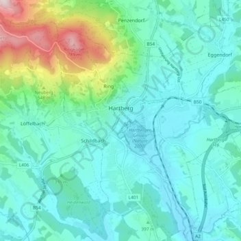
Name: Hartberg topographic map, elevation, terrain.
Location: Hartberg, Bezirk Hartberg-Fürstenfeld, Styrie, 8230, Autriche (47.24609 15.94411 47.30904 16.02669)
Average elevation: 409 m
Minimum elevation: 309 m
Maximum elevation: 823 m
Other topographic maps
Click on a map to view its topography, its elevation and its terrain.
Burgau
Autriche > Styrie > Bezirk Hartberg-Fürstenfeld
Burgau, Bezirk Hartberg-Fürstenfeld, Styrie, 8291, Autriche
Average elevation: 299 m
Neubrennten
Autriche > Styrie > Bezirk Hartberg-Fürstenfeld > Bad Loipersdorf > Neubrennten
Neubrennten, Bad Loipersdorf, Bezirk Hartberg-Fürstenfeld, Styrie, 8282, Autriche
Average elevation: 302 m
Fürstenfeld
Autriche > Styrie > Bezirk Hartberg-Fürstenfeld
Fürstenfeld, Bezirk Hartberg-Fürstenfeld, Styrie, 8280, Autriche
Average elevation: 283 m