
Leibnitz topographic map
Interactive map
Click on the map to display elevation.
About this map
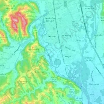
Name: Leibnitz topographic map, elevation, terrain.
Location: Leibnitz, Bezirk Leibnitz, Styrie, 8430, Autriche (46.73298 15.50220 46.80578 15.56986)
Average elevation: 297 m
Minimum elevation: 252 m
Maximum elevation: 479 m
Leibnitz se trouve à une altitude d'environ 300 mètres, dans la vallée de la Mur.
Other topographic maps
Click on a map to view its topography, its elevation and its terrain.
Großklein
Autriche > Styrie > Bezirk Leibnitz
Großklein, Bezirk Leibnitz, Styrie, 8452, Autriche
Average elevation: 373 m