
Passail topographic map
Interactive map
Click on the map to display elevation.
About this map
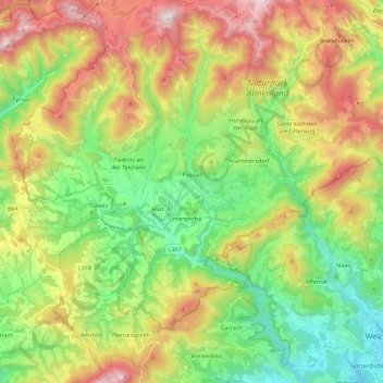
Name: Passail topographic map, elevation, terrain.
Location: Passail, Bezirk Weiz, Styrie, 8162, Autriche (47.19847 15.43653 47.35148 15.58373)
Average elevation: 875 m
Minimum elevation: 452 m
Maximum elevation: 1,524 m
Other topographic maps
Click on a map to view its topography, its elevation and its terrain.
Aschau
Autriche > Styrie > Bezirk Weiz > Fladnitz an der Teichalm
Aschau, Fladnitz an der Teichalm, Bezirk Weiz, Styrie, 8163, Autriche
Average elevation: 885 m
Tulwitzdorf
Autriche > Styrie > Bezirk Weiz > Tulwitz
Tulwitzdorf, Tulwitz, Fladnitz an der Teichalm, Bezirk Weiz, Styrie, 8163, Autriche
Average elevation: 721 m
Teichalm
Autriche > Styrie > Bezirk Weiz > Fladnitz an der Teichalm > Teichalm
Teichalm, Fladnitz an der Teichalm, Bezirk Weiz, Styrie, 8163, Autriche
Average elevation: 1,217 m
Weiz
Autriche > Styrie > Bezirk Weiz > Weiz
Weiz, Bezirk Weiz, Styrie, 8160, Autriche
Average elevation: 505 m
Naas
Autriche > Styrie > Bezirk Weiz > Naas
Naas, Bezirk Weiz, Styrie, 8160, Autriche
Average elevation: 745 m
Anger
Autriche > Styrie > Bezirk Weiz
Anger, Bezirk Weiz, Styrie, 8184, Autriche
Average elevation: 790 m