Geolocate

Cota topographic map

Click on the map to display elevation.

Cota

Cota is a municipality and town of Colombia in the Central Savanna Province of the department of Cundinamarca. Cota is part of the metropolitan area of Colombian capital Bogotá which centre is 26 kilometres (16 mi) away. The urban centre of Cota is located at an altitude of 2,566 metres (8,419 ft) and the municipality borders Chía in the north, Funza in the south, Suba, part of Bogotá in the east and Tenjo in the west.

Wikipedia (CC-BY-SA 3.0)

About this map

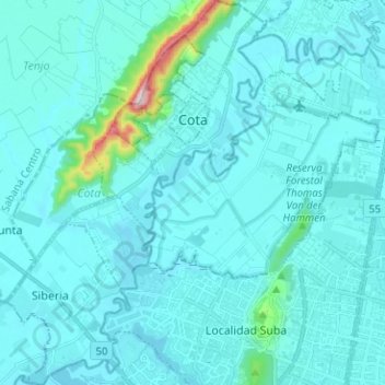
Name: Cota topographic map, elevation, terrain.

Location: Cota, Sabana Occidente, Cundinamarca, RAP (Especial) Central, Colombia (4.72259 -74.16389 4.84832 -74.07761)

Average elevation: 2,574 m

Minimum elevation: 2,532 m

Maximum elevation: 3,075 m

Other topographic maps

Click on a map to view its topography, its elevation and its terrain.

16

Colombia > Cesar > Perímetro Urbano Valledupar

Average elevation: 164 m

Río Nevado

Colombia > Boyacá > Guacamayas > El Espino

Average elevation: 2,677 m

Santo Domigo

Colombia > Boyacá > Cuítiva

Average elevation: 2,752 m

Centro Experimental Gaviotas

Colombia > Vichada > Cumaribo

Gaviotas has leveraged many forms of solar energy. They developed solar heating panels to provide hot water, which were installed in Gaviotas homes and housing developments in Medellín. The original design was not suited for Bogotá, however, since at 2,600 meters of altitude (9,000 ft) the city has a cooler…

Average elevation: 176 m

Chucuní

Colombia > Tolima > Ibagué

Average elevation: 745 m

Timbó de Betania

Colombia > Vaupés > Mitú

Average elevation: 182 m

Maimi

Colombia > Santander > Sabana de Torres

Average elevation: 147 m

Risaralda

Colombia

Average elevation: 861 m

Floridablanca

Colombia > Santander > Floridablanca > Floridablanca

Floridablanca is situated at an altitude of about 925 metres (3,035 ft) in the Eastern Ranges of the Colombian Andes, though locally the topography varies greatly. To the east of the city the higher mountains of the Andes rise above the city, thrusted upwards by the north–south-trending Bucaramanga-Santa…

Average elevation: 1,091 m

Maseta

Colombia > Caldas > La Dorada

Average elevation: 209 m

Vetas

Colombia > Santander > Vetas > Vetas

Average elevation: 3,559 m

LA FRACONIA

Colombia > Putumayo > Puerto Leguízamo

Average elevation: 186 m

Piedras Blancas - Matasano

Colombia > Antioquia > Medellín

Average elevation: 2,426 m

Gear up for your next adventure:

🛶Kayak Accessories - Essential gear for safe and fun kayaking adventures
🦶Anti-Blister Balm - Prevents friction and hotspots during long ascents
🛌Insulated Sleeping Pad - Critical thermal barrier between you and the cold ground
🥾Trail Running Boots - Durable shoes designed for trail running
🧥Waterproof Hiking Jacket - Protect yourself from rain and wind while hiking

As an Amazon Associate, this site earns from qualifying purchases at no extra cost to you.