Geolocate

Toche topographic map

Click on the map to display elevation.

About this map

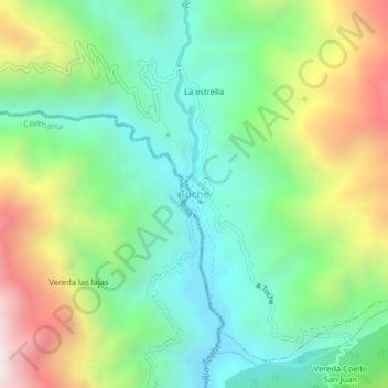
Name: Toche topographic map, elevation, terrain.

Location: Toche, Centro, Tolima, Colombia (4.50011 -75.42916 4.54011 -75.38916)

Average elevation: 2,357 m

Minimum elevation: 1,913 m

Maximum elevation: 3,203 m

Other topographic maps

Click on a map to view its topography, its elevation and its terrain.

Líbano

Colombia > Tolima

Líbano is located in the Cordillera Central, east of Nevado del Ruiz. The town is at an altitude of 1,565 metres (5,135 ft) above sea level, putting it in the tierra templada, or temperate zone, of Colombia. The area is hilly and heavily forested where it is not used for agriculture. Agriculture in the area…

Average elevation: 1,687 m

Alpujarra

Colombia > Tolima

Average elevation: 1,121 m

Lérida

Colombia > Tolima

Average elevation: 544 m

San Luis

Colombia > Tolima

Average elevation: 573 m

Rioblanco

Colombia > Tolima

Average elevation: 1,781 m

Chaparral

Colombia > Tolima

Average elevation: 1,522 m

Parque Mitológico

Colombia > Tolima > Espinal

Average elevation: 325 m

Rovira

Colombia > Tolima

Average elevation: 1,863 m

Armero - Guayabal

Colombia > Tolima

Average elevation: 672 m

Cajamarca

Colombia > Tolima

Average elevation: 2,555 m

Melgar

Colombia > Tolima

Average elevation: 643 m

Honda

Colombia > Tolima

Average elevation: 471 m

Vereda Gallego

Colombia > Tolima > Vereda Gallego

Average elevation: 518 m

Santa Isabel

Colombia > Tolima

Average elevation: 2,015 m

Gear up for your next adventure:

💡Portable Camping Lamp - Rechargeable lamp for campsite lighting
🧼Travel Hand Sanitizer - Keep hands clean when water is scarce
🌡️Emergency Mylar Blankets - Compact thermal protection for unexpected nights outdoors
🔪Outdoor Multitool - Versatile tool for repairs and food prep in the wild
🧴Bear Spray Holster - Quick-access carry for essential Canadian wilderness safety

As an Amazon Associate, this site earns from qualifying purchases at no extra cost to you.