Geolocate

Santa Isabel topographic map

Click on the map to display elevation.

About this map

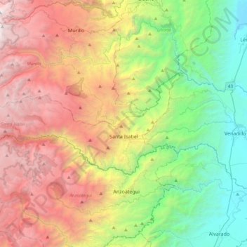
Name: Santa Isabel topographic map, elevation, terrain.

Location: Santa Isabel, Nevados, Tolima, Colombia (4.65618 -75.38864 4.81089 -75.01407)

Average elevation: 2,015 m

Minimum elevation: 260 m

Maximum elevation: 4,557 m

Other topographic maps

Click on a map to view its topography, its elevation and its terrain.

Parque Mitológico

Colombia > Tolima > Espinal

Average elevation: 325 m

Toche

Colombia > Tolima

Average elevation: 2,357 m

Alto De Letras

Colombia > Tolima

Average elevation: 1,511 m

Gaitan

Colombia > Tolima > Gaitan

Average elevation: 1,198 m

Piedras

Colombia > Tolima > Piedras

Average elevation: 415 m

Gear up for your next adventure:

🥾Lightweight Hiking Shoes - Comfortable shoes for day hikes
🧦Merino Wool Socks - Moisture-wicking comfort for long-distance hiking
🔋Solar Power Bank - Keep your GPS and devices charged during long outdoor trips
🧥Thermal Fleece Jacket - Versatile insulation for changing mountain temperatures
🪜Heavy Duty Carabiners - Multi-use clips for securing gear to your backpack

As an Amazon Associate, this site earns from qualifying purchases at no extra cost to you.