Geolocate

Lérida topographic map

Click on the map to display elevation.

About this map

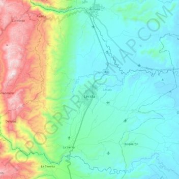
Name: Lérida topographic map, elevation, terrain.

Location: Lérida, Nevados, Tolima, RAP (Especial) Central, Colombia (4.77023 -75.01785 4.96717 -74.80910)

Average elevation: 544 m

Minimum elevation: 230 m

Maximum elevation: 1,511 m

Other topographic maps

Click on a map to view its topography, its elevation and its terrain.

Parque Mitológico

Colombia > Tolima > Espinal

Average elevation: 325 m

Toche

Colombia > Tolima

Average elevation: 2,357 m

Alto De Letras

Colombia > Tolima

Average elevation: 1,511 m

Gaitan

Colombia > Tolima > Gaitan

Average elevation: 1,198 m

Piedras

Colombia > Tolima > Piedras

Average elevation: 415 m

Gear up for your next adventure:

🧴Waterproofing Spray - Restore the DWR coating on jackets and tents
🧥Softshell Jacket - Windproof and breathable jacket for hiking
🥾Hiking Shorts - Breathable shorts suitable for summer hikes
🔥Camping Stove - Portable stoves to cook outdoors with ease
🚲Heavy Duty Bike Lock - Secure your bike at the trailhead or during stops

As an Amazon Associate, this site earns from qualifying purchases at no extra cost to you.