Geolocate

Cajamarca topographic map

Click on the map to display elevation.

About this map

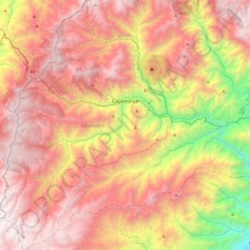
Name: Cajamarca topographic map, elevation, terrain.

Location: Cajamarca, Centro, Tolima, Colombia (4.23030 -75.60436 4.58363 -75.36676)

Average elevation: 2,555 m

Minimum elevation: 898 m

Maximum elevation: 3,841 m

Other topographic maps

Click on a map to view its topography, its elevation and its terrain.

Parque Mitológico

Colombia > Tolima > Espinal

Average elevation: 325 m

Toche

Colombia > Tolima

Average elevation: 2,357 m

Alto De Letras

Colombia > Tolima

Average elevation: 1,511 m

Piedras

Colombia > Tolima > Piedras

Average elevation: 415 m

Gaitan

Colombia > Tolima > Gaitan

Average elevation: 1,198 m

Gear up for your next adventure:

🥾Approach Boots - Comfortable boots for hiking and climbing approaches
🧢Hiking Sun Hat - Wide-brimmed protection for exposed mountain ridges
🦶Anti-Blister Balm - Prevents friction and hotspots during long ascents
🔦LED Flashlight - Powerful and long-lasting flashlight for camping and emergencies
🧥Softshell Jacket - Windproof and breathable jacket for hiking

As an Amazon Associate, this site earns from qualifying purchases at no extra cost to you.