Geolocate

Rioblanco topographic map

Click on the map to display elevation.

About this map

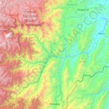
Name: Rioblanco topographic map, elevation, terrain.

Location: Rioblanco, Sur, Tolima, RAP (Especial) Central, Colombia (3.16966 -76.08498 3.77734 -75.57600)

Average elevation: 1,781 m

Minimum elevation: 416 m

Maximum elevation: 4,555 m

Other topographic maps

Click on a map to view its topography, its elevation and its terrain.

Parque Mitológico

Colombia > Tolima > Espinal

Average elevation: 325 m

Toche

Colombia > Tolima

Average elevation: 2,357 m

Alto De Letras

Colombia > Tolima

Average elevation: 1,511 m

Gaitan

Colombia > Tolima > Gaitan

Average elevation: 1,198 m

Piedras

Colombia > Tolima > Piedras

Average elevation: 415 m

Gear up for your next adventure:

🧦Hiking Liner Socks - Thin base layer to prevent friction and blisters
👖Convertible Hiking Pants - Zip-off legs to adapt to changing weather conditions
🔪Outdoor Multitool - Versatile tool for repairs and food prep in the wild
🥾Hiking Leggings - Comfortable leggings for outdoor activities
🧢Outdoor Visor - Breathable visor for sunny hikes

As an Amazon Associate, this site earns from qualifying purchases at no extra cost to you.