Geolocate

Isérables topographic map

Click on the map to display elevation.

About this map

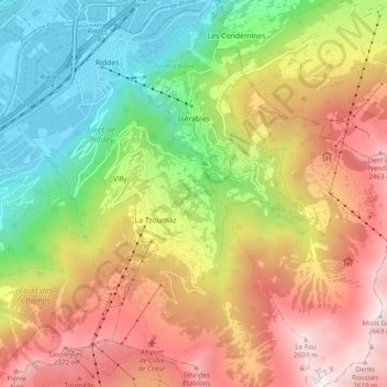
Name: Isérables topographic map, elevation, terrain.

Location: Isérables, Martigny, Wallis, 1914, Switzerland (46.11528 7.23014 46.18258 7.29556)

Average elevation: 1,504 m

Minimum elevation: 464 m

Maximum elevation: 2,709 m

Other topographic maps

Click on a map to view its topography, its elevation and its terrain.

Le Guercet

Switzerland > Wallis > Martigny > Martigny

Average elevation: 718 m

Ly

Switzerland > Wallis > Martigny > Trient

Average elevation: 2,234 m

Dugny

Switzerland > Wallis > Martigny > Ovronnaz

Average elevation: 1,074 m

La Tzoumaz

Switzerland > Wallis > Martigny

Average elevation: 1,467 m

Gear up for your next adventure:

🥽Outdoor Goggles - Protective eyewear for outdoor activities
🧊Insulated Water Bottle - Keeps drinks cold in summer and prevents freezing in winter
🔦LED Flashlight - Powerful and long-lasting flashlight for camping and emergencies
🔦LED Headtorch - Bright and durable light for night activities
🌡️Emergency Mylar Blankets - Compact thermal protection for unexpected nights outdoors

As an Amazon Associate, this site earns from qualifying purchases at no extra cost to you.