
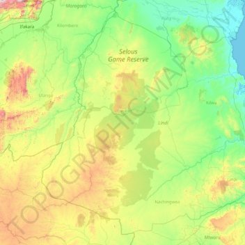
Lindi Region topographic map
Interactive map
Click on the map to display elevation.
About this map
Name: Lindi Region topographic map, elevation, terrain.
Location: Lindi Region, Coastal Zone, Tanzania (-10.73757 36.86896 -7.93453 39.98170)
Average elevation: 402 m
Minimum elevation: 0 m
Maximum elevation: 2,228 m
The region is divided into two main agro-ecological zones; the coastal zone which is the main cultivation of tree crops such as cashew, coconut and mango. These areas are Lindi and Kilwa districts respectively with an elevation of 0 to 400 meters. Roughly 10% of farmers commercially grow cashews for export. The second agro-ecological zone is the midlands where the main cultivation of crops include maize, African rice, sesame and cassava. These areas are mostly Liwale and Nachingwea districts with an elevation of 300 to 900 meters above sea level. Rearing of livestock is still low in Lindi compared to other regions.
Other topographic maps
Click on a map to view its topography, its elevation and its terrain.
Dodoma
Dodoma, Dodoma City, Dodoma Region, Central Zone, 41110, Tanzania
Average elevation: 1,144 m
Iringa
Iringa, Iringa Region, Southern Highlands Zone, Tanzania
Average elevation: 1,215 m
Kinondoni
Kinondoni, Kinondoni Municipal, Dar es Salaam, Coastal Zone, 14110, Tanzania
Average elevation: 12 m
Kingolwira
Kingolwira, Morogoro, Morogoro Region, Coastal Zone, Tanzania
Average elevation: 483 m
Ndele
Ndele, Uvinza, Kigoma Region, Western Zone, Tanzania
Average elevation: 786 m
Kiegea A
Kiegea A, Morogoro, Morogoro Region, Coastal Zone, Tanzania
Average elevation: 541 m
Maleuts
Maleuts, Makete, Njombe Region, Southern Highlands Zone, Tanzania
Average elevation: 2,204 m
Kisagani
Kisagani, Tandahimba, Mtwara Region, Coastal Zone, Tanzania
Average elevation: 234 m
Moshi
Moshi, Moshi Urban, Kilimanjaro, Northern Zone, 25107, Tanzania
Average elevation: 1,109 m
Serengeti National Park
Serengeti National Park, Ikoma, Serengeti, Mara Region, Lake Zone, Tanzania
Average elevation: 1,524 m
Mjini
Tanzania > Zanzibar Urban/West
Mjini, Zanzibar Urban/West, Zanzibar, Tanzania
Average elevation: 15 m
Uhuru Peak
Uhuru Peak, Rombo, Kilimanjaro, Northern Zone, Tanzania
Average elevation: 5,494 m
Zanzibar Urban/West
Tanzania > Zanzibar Urban/West
Zanzibar Urban/West, Zanzibar, Tanzania
Average elevation: 14 m
Lushoto
Lushoto, Tanga Region, Northern Zone, Tanzania
Average elevation: 708 m
Machame
Tanzania > Kilimanjaro > Machame
Machame, Hai, Kilimanjaro, Northern Zone, Tanzania
Average elevation: 1,417 m
Kijitonyama
Tanzania > Coastal Zone > Dar es Salaam
Kijitonyama, Dar es Salaam, Coastal Zone, Tanzania
Average elevation: 26 m
Lake Manyara
Lake Manyara, Babati, Manyara, Northern Zone, Tanzania
Average elevation: 1,174 m
Pemba
Pemba, Wete District, North Pemba, Zanzibar, Tanzania
Average elevation: 4 m
Furtwängler Glacier
Furtwängler Glacier, Scree Slope, Rombo, Kilimanjaro, Northern Zone, Tanzania
Average elevation: 5,569 m