
Make a donation
Gear up for your next adventure:
As an Amazon Associate, this site earns from qualifying purchases at no extra cost to you.
Lindi Region topographic map
Click on the map to display elevation.
Make a donation
Gear up for your next adventure:
As an Amazon Associate, this site earns from qualifying purchases at no extra cost to you.
Lindi Region
The region is divided into two main agro-ecological zones; the coastal zone which is the main cultivation of tree crops such as cashew, coconut and mango. These areas are Lindi and Kilwa districts respectively with an elevation of 0 to 400 meters. Roughly 10% of farmers commercially grow cashews for export. The second agro-ecological zone is the midlands where the main cultivation of crops include maize, African rice, sesame and cassava. These areas are mostly Liwale and Nachingwea districts with an elevation of 300 to 900 meters above sea level. Rearing of livestock is still low in Lindi compared to other regions.
Make a donation
Gear up for your next adventure:
As an Amazon Associate, this site earns from qualifying purchases at no extra cost to you.
About this map
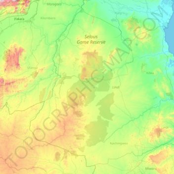
Name: Lindi Region topographic map, elevation, terrain.
Location: Lindi Region, Coastal Zone, Tanzania (-10.73757 36.86896 -7.93453 39.98170)
Average elevation: 402 m
Minimum elevation: 0 m
Maximum elevation: 2,228 m
Make a donation
Gear up for your next adventure:
As an Amazon Associate, this site earns from qualifying purchases at no extra cost to you.
Other topographic maps
Click on a map to view its topography, its elevation and its terrain.
Make a donation
Gear up for your next adventure:
As an Amazon Associate, this site earns from qualifying purchases at no extra cost to you.
Arusha
Despite its proximity to the equator, Arusha's elevation of 1,400 metres (4,600 ft) on the southern slopes of Mount Meru keeps temperatures relatively low and alleviates humidity. Cool dry air is prevalent for much of the year. The temperature typically ranges between 10 and 30 °C (50 and 86 °F) with an…
Average elevation: 1,572 m