Geolocate

Meru topographic map

Interactive map

Click on the map to display elevation.

About this map

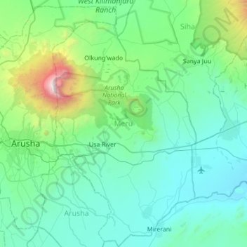
Name: Meru topographic map, elevation, terrain.

Location: Meru, Arusha, Northern Zone, 23316, Tanzania (-3.59802 36.74762 -3.05344 37.06524)

Average elevation: 1,342 m

Minimum elevation: 849 m

Maximum elevation: 4,526 m

Other topographic maps

Click on a map to view its topography, its elevation and its terrain.

Arusha

Tanzania > Arusha

Arusha, Arusha Municipal, Arusha, Northern Zone, 23103, Tanzania

Average elevation: 1,572 m

Arusha

Tanzania > Arusha

Arusha, Northern Zone, Tanzania

Average elevation: 1,349 m

Arumeru

Tanzania > Arusha

Arumeru, Arusha, Northern Zone, Tanzania

Average elevation: 1,369 m