
Thank you for supporting this site ❤️
Make a donation
Make a donation
Gear up for your next adventure:
As an Amazon Associate, this site earns from qualifying purchases at no extra cost to you.
Ndele topographic map
Click on the map to display elevation.
Thank you for supporting this site ❤️
Make a donation
Make a donation
Gear up for your next adventure:
As an Amazon Associate, this site earns from qualifying purchases at no extra cost to you.
About this map
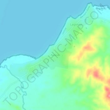
Name: Ndele topographic map, elevation, terrain.
Location: Ndele, Uvinza, Kigoma Region, Western Zone, Tanzania (-5.96838 29.87713 -5.92838 29.91713)
Average elevation: 786 m
Minimum elevation: 766 m
Maximum elevation: 858 m
Thank you for supporting this site ❤️
Make a donation
Make a donation
Gear up for your next adventure:
As an Amazon Associate, this site earns from qualifying purchases at no extra cost to you.