Geolocate

Jefferson County topographic map

Click on the map to display elevation.

About this map

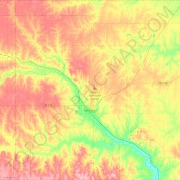
Name: Jefferson County topographic map, elevation, terrain.

Location: Jefferson County, Nebraska, United States (40.00151 -97.36925 40.35039 -96.91602)

Average elevation: 439 m

Minimum elevation: 377 m

Maximum elevation: 493 m

Other topographic maps

Click on a map to view its topography, its elevation and its terrain.

Lincoln

United States > Nebraska > Lancaster County > Lincoln

Average elevation: 387 m

Missouri River

United States > Nebraska > Cedar County

Elevations in the watershed vary widely, ranging from just over 400 feet (120 m) at the Missouri's mouth to the 14,293-foot (4,357 m) summit of Mount Lincoln in central Colorado. The river drops 8,626 feet (2,629 m) from Brower's Spring, the farthest source. Although the plains of the watershed have extremely…

Average elevation: 368 m

Millard

United States > Nebraska > Douglas County > Omaha

Average elevation: 355 m

Border Lake

United States > Nebraska > Garden County

Average elevation: 1,175 m

Bostwick

United States > Nebraska > Nuckolls County

Average elevation: 496 m

Spaulding Park

United States > Nebraska > Douglas County > Omaha

Average elevation: 331 m

Kolar Dam

United States > Nebraska > Howard County

Average elevation: 589 m

Gear up for your next adventure:

🧭Orienteering Kit - Tools for map reading and navigation in the wild
🥾Durable Hiking Shoes - Long-lasting shoes for frequent hiking
🥘Camping Cookware Set - Compact nesting pots and pans for trail cooking
🥤Collapsible Travel Cup - Saves space and weight in your mess kit
🧴Insect Repellent - Protect yourself from bugs during outdoor adventures

As an Amazon Associate, this site earns from qualifying purchases at no extra cost to you.