
Bridgeville topographic map
Click on the map to display elevation.
Bridgeville
Even more significant to the development of Bridgeville was the advent of commercial coal mining. The Pittsburgh Coal Seam was perhaps the most valuable mineral resource in North America in the late 1800s. Ranging from forty inches to six feet thick it was located at an elevation that produced outcroppings on all the hillsides in this area.
About this map
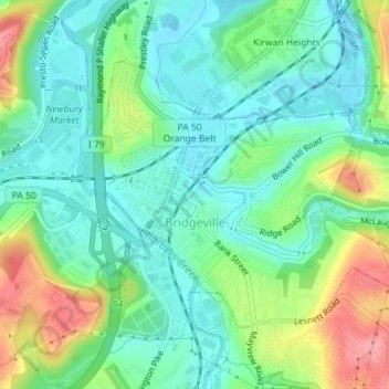
Name: Bridgeville topographic map, elevation, terrain.
Location: Bridgeville, Allegheny County, Pennsylvania, United States (40.34885 -80.12069 40.36734 -80.08798)
Average elevation: 275 m
Minimum elevation: 242 m
Maximum elevation: 344 m
Other topographic maps
Click on a map to view its topography, its elevation and its terrain.
Keown Station
United States > Pennsylvania > Allegheny County > Ross Township
Average elevation: 344 m
Champion
United States > Pennsylvania > Allegheny County > North Fayette Township
Average elevation: 360 m
Tortilla Flats
United States > Pennsylvania > Allegheny County > Sewickley Heights
Average elevation: 333 m
Coraopolis Heights
United States > Pennsylvania > Allegheny County > Findlay Township
Average elevation: 320 m
Central Highlands
United States > Pennsylvania > Allegheny County > Elizabeth Township
Average elevation: 327 m
Sturgeon
United States > Pennsylvania > Allegheny County > North Fayette Township
Average elevation: 334 m
Allison Park
United States > Pennsylvania > Allegheny County > Hampton Township
Average elevation: 324 m
Highland Park Reservoir No. 2
United States > Pennsylvania > Allegheny County > Pittsburgh
Average elevation: 275 m
Neville Island
United States > Pennsylvania > Allegheny County > Neville Township
Average elevation: 289 m
Cochrans Mill
United States > Pennsylvania > Allegheny County > Jefferson Hills
Average elevation: 311 m
Allegheny River Lock and Dam No. 2
United States > Pennsylvania > Allegheny County > O'Hara Township
Average elevation: 268 m
Observatory Hill
United States > Pennsylvania > Allegheny County > Pittsburgh
Average elevation: 319 m
Stoneybrooke Woods
United States > Pennsylvania > Allegheny County > Cheswick
Average elevation: 283 m
Lovedale
United States > Pennsylvania > Allegheny County > Elizabeth Township
Average elevation: 298 m
Dorseyville
United States > Pennsylvania > Allegheny County > Indiana Township
Average elevation: 325 m