
Hausham topographic map
Click on the map to display elevation.
Hausham
Hausham liegt direkt am Fuß des Alpenrandes. Der Gebirgszug des Hausberges Huberspitz (1052 m) über die noch zu Hausham gehörende Gindelalm (1334 m) bis zur Neureuth bei Tegernsee (1261 m) grenzt die Alpen scharf von der Alpenvorebene ab. In der Dorfmitte erhebt sich eine vom Gebirgszug getrennte Anhöhe. Sie heißt Haushamer Alm und ist ein ungewöhnlich großer Moränenhügel aus der Eiszeit.
About this map
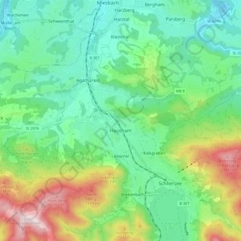
Name: Hausham topographic map, elevation, terrain.
Location: Hausham, Landkreis Miesbach, Bayern, 83734, Deutschland (47.72695 11.78441 47.78060 11.89438)
Average elevation: 854 m
Minimum elevation: 649 m
Maximum elevation: 1,328 m
Other topographic maps
Click on a map to view its topography, its elevation and its terrain.
Spitzingsee
Deutschland > Bayern > Landkreis Miesbach > Spitzingsee
Der Spitzingsee liegt etwa fünf Kilometer südlich des Schliersees und wenige hundert Meter südlich des Spitzingsattels auf 1084 m Höhe in den Schlierseer Bergen, Mangfallgebirge, Bayerische Alpen. Mit 28,3 Hektar (0,28 km²) Fläche ist er einer der größten Bergseen Bayerns. Die Seetiefe beträgt maximal…
Average elevation: 1,262 m
Wendelstein
Deutschland > Bayern > Landkreis Miesbach > Fischbachau
Der Jahresniederschlag liegt bei 1713 mm in der Referenzperiode 1961–1990 und ist damit im deutschlandweiten Vergleich extrem hoch, da er in das obere Zwanzigstel der in Deutschland erfassten Werte fällt. An 99 % der Messstationen des Deutschen Wetterdienstes werden niedrigere Werte registriert. Im Zeitraum…
Average elevation: 1,374 m
Wallberg
Deutschland > Bayern > Landkreis Miesbach > Rottach-Egern
Der Anstieg von der Wallbergbahn-Talstation bei Rottach-Egern führt über einen Sattel links vorbei am Setzberg (1706 m) zur Bergstation der Wallbergbahn. Das dortige Panoramarestaurant Wallberg liegt in 1623 m Höhe. Nach weiteren 100 Höhenmetern erreicht man über einen Geröll- und Felspfad in etwa…
Average elevation: 1,215 m
Sonderdilching
Deutschland > Bayern > Landkreis Miesbach > Weyarn > Sonderdilching
Average elevation: 631 m
Taubenberg
Deutschland > Bayern > Landkreis Miesbach > Warngau
Der Taubenberg ist ein Berg mit 896 m Höhe und einer Ausdehnung von 1847 ha auf dem Gebiet der Gemeinde Warngau, zu einem kleineren Teil auch auf dem Gebiet der Gemeinde Valley, im Landkreis Miesbach. Er liegt abgesetzt vor den Tegernseer Bergen der Bayerischen Voralpen und ist ein beliebtes Wanderziel und…
Average elevation: 783 m
Wildbad Kreuth
Deutschland > Bayern > Landkreis Miesbach > Kreuth
2015 gab die Hanns-Seidel-Stiftung bekannt, dass der Eigentümer die jährliche Pacht von eher symbolischen 84.000 Euro auf 630.000 Euro erhöhen wolle, jeweils zuzüglich aller Unterhaltskosten. Die Stiftung erklärte, dass sie die Pacht des Gebäudes unter diesen Umständen nicht fortsetzen könne. Die…
Average elevation: 1,021 m
Taubenstein
Deutschland > Bayern > Landkreis Miesbach > Bayrischzell
Der Berg ist als Bergwanderung, die im Gipfelbereich aber Trittsicherheit erfordert, zu Fuß am schnellsten vom Spitzingsattel zu erreichen (Aufstieg: 1:45 Stunden, Abstieg 1:30 Stunden, 566 Höhenmeter).In der Westwand des Taubensteingipfels gibt es verschiedene Kletterrouten. Über den Südgrat kann man den…
Average elevation: 1,512 m
Fentberg
Deutschland > Bayern > Landkreis Miesbach > Valley
Der Fentberg bildet das nordostseitige Ende des U-förmigen Taubenbergkamms. Nach Westen führt ein Höhenweg über Nüchternbrunn bis zum höchsten Punkt des Kamms. Südlich unterhalb liegt das Farnbachtal. An seiner Ostseite oberhalb des Mangfalltals liegt die Einöde mit gleichem Namen Fentberg.
Average elevation: 710 m
Anderlmühle
Deutschland > Bayern > Landkreis Miesbach > Hohendilching > Anderlmühle
Average elevation: 637 m
Bayrischzell
Deutschland > Bayern > Landkreis Miesbach > Bayrischzell
Die Gemeinde liegt am Beginn des Leitzachtales auf einer Seehöhe zwischen 750 und 1884 Metern inmitten der bayerischen Voralpen. Das Talgebiet ist landwirtschaftlich geprägt, das übrige Gemeindegebiet gebirgig mit zahlreichen Almflächen und großen Waldgebieten. Markantester Berg und Hausberg von…
Average elevation: 1,077 m