Geolocate

Rotwand topographic map

Click on the map to display elevation.

About this map

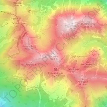
Name: Rotwand topographic map, elevation, terrain.

Location: Rotwand, Bayrischzell, Landkreis Miesbach, Bayern, Deutschland (47.65016 11.93437 47.65026 11.93447)

Average elevation: 1,577 m

Minimum elevation: 1,115 m

Maximum elevation: 1,871 m

Gear up for your next adventure:

Family Camping Tent - Spacious tent suitable for family camping trips
🧭GPS Handheld Device - Reliable GPS navigation for outdoor adventures
🧦Crew Hiking Socks - Comfortable socks for long-distance hikes
🔦LED Headtorch - Bright and durable light for night activities
🧭GPS Outdoor Watch - Smart watch for navigation and fitness tracking in nature

As an Amazon Associate, this site earns from qualifying purchases at no extra cost to you.