Geolocate

Laim topographic map

Click on the map to display elevation.

About this map

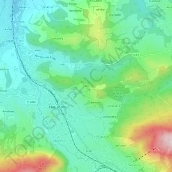
Name: Laim topographic map, elevation, terrain.

Location: Laim, Hausham, Landkreis Miesbach, Bayern, 83734, Deutschland (47.73561 11.82930 47.77561 11.86930)

Average elevation: 827 m

Minimum elevation: 707 m

Maximum elevation: 1,130 m

Other topographic maps

Click on a map to view its topography, its elevation and its terrain.

Loidlsee

Deutschland > Bayern > Landkreis Miesbach > Hausham

Average elevation: 835 m

Gear up for your next adventure:

🧊Insulated Water Bottle - Keeps drinks cold in summer and prevents freezing in winter
🧭Orienteering Kit - Tools for map reading and navigation in the wild
🧥Ultralight Puffy Jacket - Maximum warmth that packs down to the size of an orange
🧥Waterproof Hiking Jacket - Protect yourself from rain and wind while hiking
🛶Canoe Life Vest - Safety vest for water sports

As an Amazon Associate, this site earns from qualifying purchases at no extra cost to you.