Geolocate

Sellrain topographic map

Click on the map to display elevation.

About this map

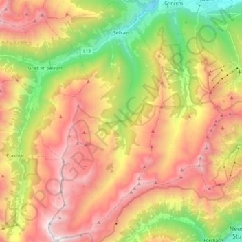
Name: Sellrain topographic map, elevation, terrain.

Location: Sellrain, Bezirk Innsbruck-Land, Tyrol, 6181, Austria (47.10572 11.14850 47.23050 11.24550)

Average elevation: 1,893 m

Minimum elevation: 791 m

Maximum elevation: 2,991 m

Other topographic maps

Click on a map to view its topography, its elevation and its terrain.

Nordkette

Austria > Tyrol > Bezirk Innsbruck-Land > Rum

Average elevation: 1,363 m

Medraz

Austria > Tyrol > Bezirk Innsbruck-Land > Fulpmes

Average elevation: 1,277 m

Gschnitztal

Austria > Tyrol > Bezirk Innsbruck-Land > Trins

Average elevation: 1,829 m

Kreuzjöchl

Austria > Tyrol > Bezirk Innsbruck-Land > Navis

Average elevation: 2,197 m

Gaistal

Austria > Tyrol > Bezirk Innsbruck-Land > Leutasch

Average elevation: 1,731 m

Klamm

Austria > Tyrol > Bezirk Innsbruck-Land > Leutasch

Average elevation: 1,366 m

Hohe Munde Ostgipfel

Austria > Tyrol > Bezirk Innsbruck-Land > Telfs

Average elevation: 1,794 m

Hochwanner

Austria > Tyrol > Bezirk Innsbruck-Land > Leutasch

Average elevation: 1,968 m

Praxmar

Austria > Tyrol > Bezirk Innsbruck-Land

Average elevation: 2,078 m

Juifenau

Austria > Tyrol > Bezirk Innsbruck-Land > Gries im Sellrain

Average elevation: 1,855 m

Fotschertal

Austria > Tyrol > Bezirk Innsbruck-Land > Sellrain

Average elevation: 1,970 m

Gurgl

Austria > Tyrol > Bezirk Innsbruck-Land > Leutasch

Average elevation: 1,604 m

Gear up for your next adventure:

💡Compact LED Flashlight - Powerful and portable flashlight for outdoor use
🔭Outdoor Binoculars - Lightweight binoculars for birdwatching and hiking
🔦UV Flashlight - Detect minerals or specific insects in the dark
Camping Coffee Maker - Brew fresh coffee anywhere on the topographic map
🧦Merino Wool Socks - Moisture-wicking comfort for long-distance hiking

As an Amazon Associate, this site earns from qualifying purchases at no extra cost to you.